Toggle navigation
LMEC Home
Exhibitions
Georeferencing
Tools for Teachers
Collections
My Favorites
Sign Up / Log In
Search
Search the map portal
Map Collection
Map Collection
Map Sets
Search
Search
Search for
Search In
All Fields
Creator
Title
Subject
Place
Search All Digital Collections
Advanced Search
297 Results
My Search
Start Over
1780
Remove constraint 1780
Filter your Search
Place
North and Central America
259
United States
180
Canada
40
New York
34
Charleston (county)
31
Charleston
27
South Carolina
25
New Jersey
19
more
Place
»
Topic
United States--History--Revolution, 1775-1783--Maps
54
Manuscript maps--Early works to 1800
22
Charleston (S.C.)--Maps
11
Charleston (S.C.)--Siege, 1780--Maps
9
Fortification--Newfoundland and Labrador--St. John's--Maps, Manuscript--Early works to 1800
9
Harbors--Newfoundland and Labrador--St. John's--Maps, Manuscript--Early works to 1800
9
Military art and science--Newfoundland and Labrador--St. John's--Maps, Manuscript--Early works to 1800
9
St. John's (N.L.)--Maps, Manuscript--Early works to 1800
9
more
Topic
»
Date
Date range begin
–
Date range end
Current results range from
1711
to
1909
View distribution
Creator
Skinner, Monier
28
Skinner, William, 1700-1780
28
Des Barres, Joseph F. W. (Joseph Frederick Wallet), 1722-1824
25
Faden, William, 1749-1836
16
André, John, 1751-1780
11
Bonne, Rigobert, 1727-1794
8
Carver, Jonathan, 1710-1780
6
Ferguson, Patrick, 1744-1780
6
more
Creator
»
Format
Maps/Atlases
291
Manuscripts
71
Prints
5
Drawings/Illustrations
1
Georeferenced
Yes
7
No
290
Collection
American Revolutionary War-Era Maps
266
Norman B. Leventhal Map & Education Center Collection
66
William L. Clements Library Collection
65
Library of Congress Collection
63
British Library Collection
33
Maritime Charts and Atlases
27
Richard H. Brown Revolutionary War Map Collection at Mount Vernon
26
Boston and New England Maps
13
more
Collection
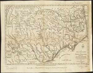
»
Available to use
Creative Commons license
142
No known restrictions
66
Search Constraints
Sort by relevance
relevance
title
date (asc)
date (desc)
Number of results to display per page
20 per page
10
per page
20
per page
50
per page
100
per page
View results as:
grid view
map view
Search Results
121.
An accurate map of New York in North America from a late survey
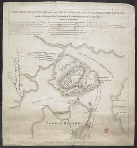
122.
A SKETCH OF THE ACTION BETWEEN THE BRITISH FORCES AND THE AMERICAN PROVINCIALS, on the Heights of the Peninsula of Charlestown,...
123.
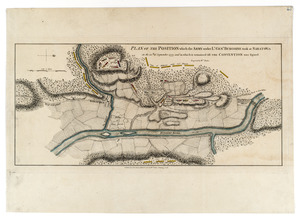
Plan of the position which the army under Lt. Genl. Burgoine took at Saratoga on the 10th of September, 1777, and in which it...
124.
A map of such parts of Georgia and South Carolina as tend to illustrate the progress and operations of the British Army, &c
125.
A new and accurate map of Connecticut and Rhode Island from the best authorities
126.
A new and accurate map of New Jersey, from the best authorities
127.
A Plan of Charles Town the capitol of South Carolina, : with the harbour, islands, and forts; the attack on Fort Sulivan, by...
128.
[Southwest coast of Nova Scotia from Cape Sable to Cape St. Mary]
129.
A New and accurate map of the chief parts of South Carolina, and Georgia
130.
Sketch of the harbour of Charles Town
131.
Carte du Golphe du Mexique et des isles Antilles : reduite de la grande carte angloise de Popple
132.
A new and accurate map of North Carolina, and part of South Carolina, with the field of battle between Earl Cornwalis and...
133.
A new map of the province of Quebec, : according to the Royal proclamation, of the 7th of October 1763
134.
West Indies, : with the harbour & fort of Omoa. From the best authorities
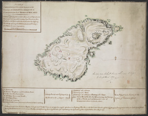
135.
PLAN of CARBONERA ISLAND situated at the Entrance of CARBONERA HARBOUR in CONCEPTION BAY NEWFOUNDLAND
136.
A chorographical map of the northern department of North-America : drawn from the latest and most accurate observations
137.
A map of the country in which the army under Lt. General Burgoyne acted in the campaign of 1777 : shewing the marches of the...
138.
A new and correct map of North America : in which the places of the principal engagements during the present war are accurately...
139.
A new and correct map of North America : in which the places of the principal engagements during the present war are accurately...
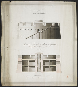
140.
ELEVATION and SECTION of the TOWER at POINT PLEASANT
‹ Prev
Next ›
1
2
3
4
5
6
7
8
9
10
11
…
14
15


![[Southwest coast of Nova Scotia from Cape Sable to Cape St. Mary]](https://bpldcassets.blob.core.windows.net/derivatives/images/commonwealth:t722hs72c/image_thumbnail_300.jpg)