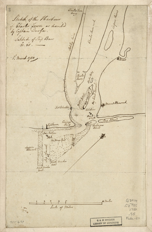
Sketch of the harbour of Charles Town
This map is also available in American Revolutionary Geographies Online (ARGO), a collections portal especially built for material relating to the American Revolutionary War Era. Visit ARGO to learn more about this item and explore the historical geography of North America in the late eighteenth century.
Item Information
- Title:
- Sketch of the harbour of Charles Town
- Creator:
- Durfee, Captain
- Name on Item:
-
as described by Captain Durfee. Latitude of ship barr 32⁰:38ʹ 1st. March 1780
- Date:
-
[1780]
- Format:
-
Maps/Atlases
Manuscripts
- Location:
- Library of Congress Geography and Map Division
- Collection (local):
-
Library of Congress Collection
- Subjects:
-
Harbors--South Carolina--Charleston--Maps--Early works to 1800
Manuscript maps
Charleston (S.C.)--Maps--Early works to 1800
- Places:
-
Charleston (county)Charleston Harbor (bay)
Charleston (county)Charleston
- Extent:
- 1 manuscript map on sheet 30 x 19 cm.
- Terms of Use:
-
No known copyright restrictions.
This work is licensed for use under a Creative Commons Attribution Non-Commercial Share Alike License (CC BY-NC-SA).

- Scale:
-
Scale ca. 1:166,000
- Language:
-
English
- Catalog Record:
-
https://lccn.loc.gov/gm71000639
- Notes:
-
Manuscript, pen-and-ink.
Has watermark.
Oriented with north toward the upper right.
Depths shown by soundings.
- Notes (date):
-
This date is inferred.
- Notes (citation):
-
LC Maps of North America, 1750-1789, 1550
- Identifier:
-
ar155000


![Armstrong C[ount]y](https://bpldcassets.blob.core.windows.net/derivatives/images/commonwealth:q524ng353/image_thumbnail_300.jpg)

