Toggle navigation
LMEC Home
Exhibitions
Georeferencing
Tools for Teachers
Collections
My Favorites
Sign Up / Log In
Search
Search the map portal
Map Collection
Map Collection
Map Sets
Search
Search
Search for
Search In
All Fields
Creator
Title
Subject
Place
Search All Digital Collections
Advanced Search
140 Results
My Search
Start Over
vermont
Remove constraint vermont
Filter your Search
Place
North and Central America
132
Vermont
58
United States
53
New England
32
New York
21
New Hampshire
18
Massachusetts
13
Canada
8
more
Place
»
Topic
Vermont--Maps
30
New England--Maps
22
Railroads--New England--Maps
12
New Hampshire--Maps
11
Long Trail (Vt.)--Maps
9
New York (State)--Maps
9
Trails--Vermont--Maps
9
Vermont--Maps--Early works to 1800
8
more
Topic
»
Date
Date range begin
–
Date range end
Current results range from
1744
to
2015
View distribution
Creator
Burleigh, L. R., 1853-1923
10
Congdon, Herbert Wheaton, 1876-1965
9
United States. Post Office Dept
7
Faden, William, 1749-1836
5
Walling, Henry Francis, 1825-1888
5
Cram, George Franklin, 1841-1928
4
Doolittle, Amos, 1754-1832
4
Green Mountain Club
4
more
Creator
»
Format
Maps/Atlases
139
Manuscripts
13
Objects/Artifacts
1
Prints
1
Georeferenced
Yes
18
No
122
Collection
Norman B. Leventhal Map Center Collection
102
Boston and New England Maps
68
American Revolutionary War-Era Maps
49
Urban Maps
17
William L. Clements Library Collection
7
American Antiquarian Society Collection
6
British Library Collection
5
Library of Congress Collection
5
more
Collection
»
Available to use
No known restrictions
103
Creative Commons license
18
Search Constraints
Sort by relevance
relevance
title
date (asc)
date (desc)
Number of results to display per page
20 per page
10
per page
20
per page
50
per page
100
per page
View results as:
grid view
map view
Search Results
101.
A plan of the division line between the provinces of New-York and Quebec : In the 45th degree of north latitude. Survey'd in...
102.
A chorographical map of the northern department of North-America
103.
A map of the inhabited part of Canada from the French surveys : with the frontiers of New York and New England from the large...
104.
A map of the inhabited part of Canada from the French surveys : with the frontiers of New York and New England from the large...
105.
An accurate map of His Majesty's province of New-Hampshire in New England : taken from actual surveys of all the inhabited...
106.
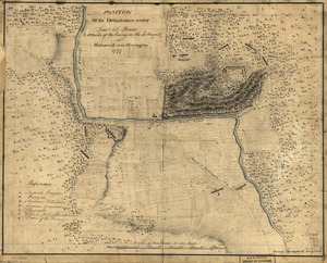
Position of the detachment under Lieut't Col. Baum & attacks of the enemy on the 16th August at Walmscock near Benington, 1777
107.
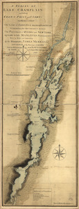
A survey of Lake Champlain including Crown Point and St. Iohn's : on which is fixed the line of forty five degrees north...
108.
A Correct Plan of the Province of New Hampshire together with part of Hudsons River from Albany to Lake George and from thence...
109.
Lake Champlain streamline ferries : direct routes to Whiteface Mtn., Ausable Chasm, scenic short-cuts between Green Mountains,...
110.
French draught of Lake Champlain & Lake George with remarks of an English prisoner who return'd from Quebec to Fort Edward by...
111.
New England fishery, recreation and scenic resources
112.
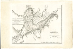
Plan of the action at Huberton under Brigadier Genl. Frazer, supported by Major Genl. Reidesel, on the 7th July 1777
113.
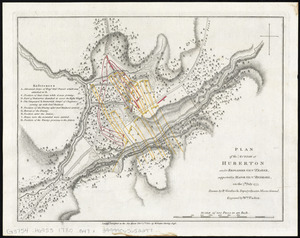
Plan of the action at Huberton under Brigadier Genl. Frazer, supported by Major Genl. Reidesel, on the 7th July 1777
114.
Map showing the proposed rail roads from Boston to Burlington, from Hale's map of New England
115.
Townsend's Patent folding globe
116.
The world
117.
Plat of the seven ranges of townships being part of the territory of the United States n.w. of the Ohio River which by a late...
118.
United States of Nth. America : carte des Etats-Unis de l'Amérique Septentrionale
119.
A map of the United States of North America : drawn from a number of critical researches
120.
United States of America
‹ Prev
Next ›
1
2
3
4
5
6
7