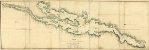
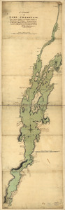
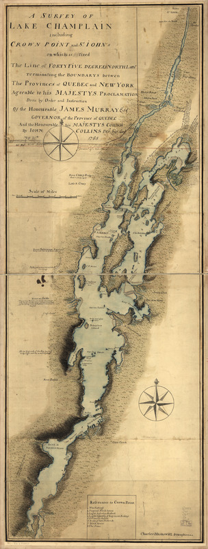
A survey of Lake Champlain including Crown Point and St. Iohn's : on which is fixed the line of forty five degrees north lattit. terminating the boundarys betwe[e]n the provinces of Quebec and New York agre[e]able to his Majesty's proclamation done by order and instruction of the Honourable James Murray, esqr., Governor of the Province of Quebec and the Honourable His Majestys Council
This map is also available in American Revolutionary Geographies Online (ARGO), a collections portal especially built for material relating to the American Revolutionary War Era. Visit ARGO to learn more about this item and explore the historical geography of North America in the late eighteenth century.
Item Information
- Title:
- A survey of Lake Champlain including Crown Point and St. Iohn's : on which is fixed the line of forty five degrees north lattit. terminating the boundarys betwe[e]n the provinces of Quebec and New York agre[e]able to his Majesty's proclamation done by order and instruction of the Honourable James Murray, esqr., Governor of the Province of Quebec and the Honourable His Majestys Council
- Creator:
- Collins, John, -1795
- Contributor:
- Murray, James, 1721-1794
- Contributor:
- Blaskowitz, Charles
- Name on Item:
-
by Iohn Collins, depy. surv. genl., May 21th 1765. Charles Blaskowitz, draughtsman
- Date:
-
[1765]
- Format:
-
Maps/Atlases
Manuscripts
- Location:
- Library of Congress Geography and Map Division
- Collection (local):
-
Library of Congress Collection
- Subjects:
-
Champlain, Lake--Maps, Manuscript--Early works to 1800
Fortification--New York (State)--Crown Point--Maps--Early works to 1800
Crown Point (N.Y.)--Buildings, structures, etc--Maps--Early works to 1800
New York (State)--Boundaries--Québec (Province)--Maps--Early works to 1800
Québec (Province)--Boundaries--New York (State)--Maps--Early works to 1800
Vermont--Boundaries--Québec (Province)--Maps--Early works to 1800
Québec (Province)--Boundaries--Vermont--Maps--Early works to 1800
- Places:
-
CanadaQuebec (province)
Vermont
Essex (county)Crown Point
Champlain, Lake
- Extent:
- 1 manuscript map : hand color, 126 x 47 cm.
- Terms of Use:
-
No known copyright restrictions.
This work is licensed for use under a Creative Commons Attribution Non-Commercial Share Alike License (CC BY-NC-SA).

- Scale:
-
Scale ca. 1:127,000
- Language:
-
English
- Catalog Record:
-
https://lccn.loc.gov/73691803
- Notes:
-
Manuscript, pen-and-ink and watercolor.
Relief shown pictorially and by shading.
Sectioned and mounted on cloth backing.
In pencil, lower left margin: No. 10.
Includes descriptive notes and "References to Crown Point."
- Notes (date):
-
This date is inferred.
- Notes (citation):
-
LC Maps of North America, 1750-1789, 1074
- Identifier:
-
ar107400z


![S[i]r: This is minuts of the fort at Crown Point and of the redouts built round it; which I took on the mountain to the west of Crown Point abt. a miles distance](https://bpldcassets.blob.core.windows.net/derivatives/images/commonwealth:q524nd85w/image_thumbnail_300.jpg)