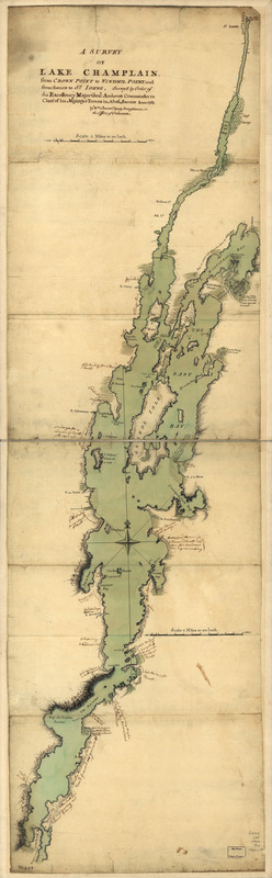
A survey of Lake Champlain, from Crown Point to Windmil Point, and from thence to St. Iohns
This map is also available in American Revolutionary Geographies Online (ARGO), a collections portal especially built for material relating to the American Revolutionary War Era. Visit ARGO to learn more about this item and explore the historical geography of North America in the late eighteenth century.
Item Information
- Title:
- A survey of Lake Champlain, from Crown Point to Windmil Point, and from thence to St. Iohns
- Creator:
- Brasier, William
- Name on Item:
-
Survey'd by order of His Excellency Major Genl. Amherst, Commander in Chief of His Majesty's forces in North America, anno 1762. By Wm. Brasier, deputy draughtsman, in the Office of Ordnance
- Date:
-
[1762]
- Format:
-
Maps/Atlases
Manuscripts
- Location:
- Library of Congress Geography and Map Division
- Collection (local):
-
Library of Congress Collection
- Subjects:
-
Champlain, Lake--Maps, Manuscript--Early works to 1800
- Places:
-
Champlain, Lake
- Extent:
- 1 manuscript map : hand color, on sheet 131 x 38 cm.
- Terms of Use:
-
No known copyright restrictions.
This work is licensed for use under a Creative Commons Attribution Non-Commercial Share Alike License (CC BY-NC-SA).

- Scale:
-
Scale 1:126,720
- Language:
-
English
- Catalog Record:
-
https://lccn.loc.gov/gm71000607
- Notes:
-
Title on label on verso: Lake Champlain, from Crown Point to St. Iohns.
Manuscript, pen-and-ink and watercolor.
Has watermarks.
Relief shown by hachures.
Includes numerous annotations in a different hand.
- Notes (date):
-
This date is inferred.
- Notes (citation):
-
LC Maps of North America, 1750-1789, 1072
- Identifier:
-
ar107200z

![[A map of Lake Champlain and Lake George, showing the route from Fort Edward to Montreal]](https://bpldcassets.blob.core.windows.net/derivatives/images/commonwealth:hx11z3312/image_thumbnail_300.jpg)
![[A map of the southern part of the Lake Champlain, from "Tienderoga fort" to Crown Point]](https://bpldcassets.blob.core.windows.net/derivatives/images/commonwealth:6108vv78r/image_thumbnail_300.jpg)
