United States of Nth. America : carte des Etats-Unis de l'Amérique Septentrionale
Item Information
- Title:
- United States of Nth. America : carte des Etats-Unis de l'Amérique Septentrionale
- Description:
-
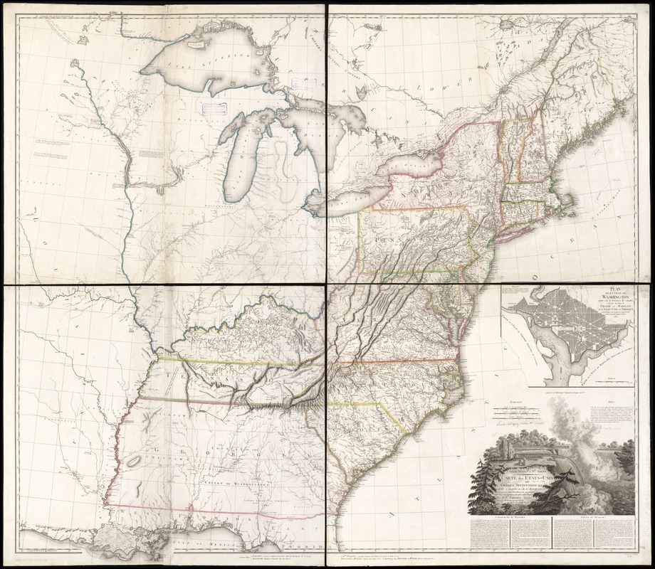
We Are One: Based on a map published by a British mapmaker in 1796, Pierre Antoine Tardieu prepared this 1802 version for a French audience. Tardieu emphasized the geography of the United States. Adorned with a cartouche highlighting Niagara Falls, a new American icon, it defines the nation’s boundaries and depicts the states of Vermont, Kentucky, and Tennessee. An inset showcases Pierre L’Enfant’s plan for the nation’s capital in Washington, DC. The plan, inspired by Baroque city designs, features broad diagonal avenues imposed on a grid street system, reflecting the city’s proposed function as a ceremonial seat of government.
- Creator:
- Tardieu, Pierre Antoine, 1784-1869
- Name on Item:
-
copiée et gravée sur celle d'Arrowsmith ; corrigée et considérablement augmentée d'après les renseignements les plus authentiques par P.F. Tardieu ; Chles. Picquet, Geographe Graveur ; Treuttel et Wurtz ; ecrit par J.J. Pachoux.
- Date:
-
1802
- Format:
-
Maps/Atlases
- Location:
-
Boston Public Library
Norman B. Leventhal Map & Education Center - Collection (local):
-
Norman B. Leventhal Map & Education Center Collection
- Subjects:
-
United States--Maps
- Places:
-
United States
- Extent:
- 1 map : hand col. ; 124 x 138 cm.
- Terms of Use:
-
No known copyright restrictions.
No known restrictions on use.
- Publisher:
-
Paris :
Treuttel et Wurtz
- Scale:
-
Scale [ca. 1:1,860,000].
- Language:
-
English
French
- Notes:
-
Relief shown pictorially.
Includes text, decorative cartouche, and inset "Plan de la ville de Washington située sur le Territoire de Columbia."
In English and French.
This map can be viewed as a georeferenced overlay in an interactive application made especially for We Are One: Mapping America's Road from Revolution to Independence http://d2o8owo4k087al.cloudfront.net/index.html?mapId=99.
- Notes (exhibitions):
-
Exhibited: "We Are One: Mapping America's Road from Revolution to Independence" organized by the Norman B. Leventhal Map Center at the Boston Public Library, 2015.
- Identifier:
-
06_01_006229
- Call #:
-
G3700 1802 .T37
- Barcode:
-
39999065671669


