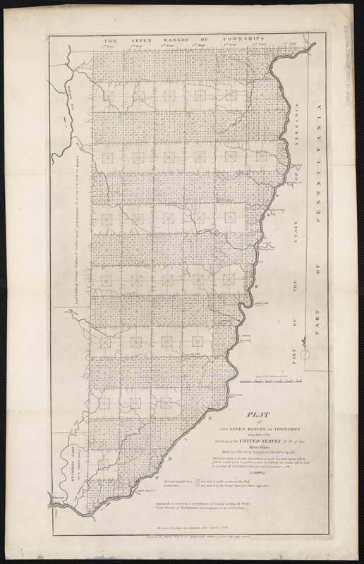
Plat of the seven ranges of townships being part of the territory of the United States n.w. of the Ohio River which by a late act of Congress are directed to be sold
This map is also available in American Revolutionary Geographies Online (ARGO), a collections portal especially built for material relating to the American Revolutionary War Era. Visit ARGO to learn more about this item and explore the historical geography of North America in the late eighteenth century.
Item Information
- Title:
- Plat of the seven ranges of townships being part of the territory of the United States n.w. of the Ohio River which by a late act of Congress are directed to be sold
- Description:
-
In addition to featuring maps of individual states (such as the map of Vermont), Carey added maps of newly organized territories in his atlases. For example, this map depicts part of southeastern Ohio divided into seven ranges of six-mile-square townships, many of which were further subdivided into one-mile-square sections. This was the beginning of America’s rectangular survey system, which became the standard practice for surveying and selling lands in the public lands west of the Appalachian Mountains. Americans, speculators and settlers alike could use maps like this one to determine which parcels of land were available for purchase.
- Creator:
- Hutchins, Thomas, 1730-1789
- Cartographer:
- Hutchins, Thomas, 1730-1789
- Engraver:
- Barker, W. (William), active 1795-1803
- Publisher:
- Carey, Mathew, 1760-1839
- Name on Item:
-
surveyed in conformity to an Ordinance of Congress of May 20th, 1785, under direction of Thos. Hutchins, late geographer to the United States ; W. Barker, sculp.
- Date:
-
[1800]
- Format:
-
Maps/Atlases
- Location:
-
Boston Public Library
Norman B. Leventhal Map Center - Collection (local):
-
Norman B. Leventhal Map Center Collection
- Subjects:
-
Land grant--Ohio--Maps
Ohio--Maps
- Places:
-
Ohio
- Extent:
- 1 map ; 62 x 34 cm
- Terms of Use:
-
No known copyright restrictions.
No known restrictions on use.
- Publisher:
-
[Philadelphia] :
[Mathew Carey]
- Scale:
-
Scale 253,440
- Language:
-
English
- Notes:
-
In upper left: 46.
Map 46 in his Carey's general atlas. Philadelphia : Mathew Carey, 1800.
This map can be viewed as a georeferenced overlay in an interactive application made especially for We Are One: Mapping America's Road from Revolution to Independence http://d2o8owo4k087al.cloudfront.net/index.html?mapId=92.
- Notes (date):
-
This date is inferred.
- Notes (exhibitions):
-
Exhibited: "We Are One: Mapping America's Road from Revolution to Independence" organized by the Norman B. Leventhal Map Center at the Boston Public Library, 2015.
- Identifier:
-
06_01_004565
- Call #:
-
G1015 .C3 1800x
- Barcode:
-
30000005058226


