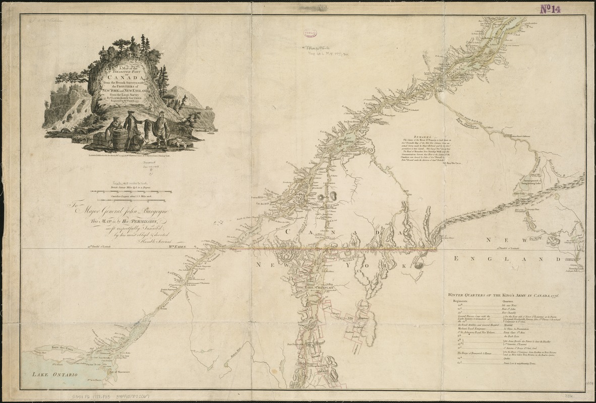
A map of the inhabited part of Canada from the French surveys : with the frontiers of New York and New England from the large survey by Claude Joseph Sauthier
This map is also available in American Revolutionary Geographies Online (ARGO), a collections portal especially built for material relating to the American Revolutionary War Era. Visit ARGO to learn more about this item and explore the historical geography of North America in the late eighteenth century.
Item Information
- Title:
- A map of the inhabited part of Canada from the French surveys : with the frontiers of New York and New England from the large survey by Claude Joseph Sauthier
- Creator:
- Faden, William, 1749-1836
- Name on Item:
-
engraved by Wm. Faden.
- Date:
-
1777
- Format:
-
Maps/Atlases
- Location:
-
Boston Public Library
Norman B. Leventhal Map & Education Center - Collection (local):
-
Norman B. Leventhal Map & Education Center Collection
- Subjects:
-
Canada--Boundaries--United States--Maps--Early works to 1800
United States--Boundaries--Canada--Maps--Early works to 1800
Québec (Province)--Maps--Early works to 1800
New York (State)--Maps--Early works to 1800
Vermont--Maps--Early works to 1800
United States--History--Revolution, 1775-1783--British forces
- Places:
-
CanadaQuebec (province)
New York
Vermont
- Extent:
- 1 map : hand col. ; 57 x 85 cm.
- Terms of Use:
-
No known copyright restrictions.
No known restrictions on use.
- Publisher:
-
London :
Wm. Faden
- Scale:
-
Scale [ca. 1:800,000]
- Language:
-
English
- Notes:
-
Relief shown by hachures and pictorially.
Shows the Canadian-United States border from Lake Ontario along the St. Lawrence River to 45⁰ N. latitude, east to the Connecticut River, and northeast along the "Height of the land." Coverage of areas away from the boundary is focused upon the southern portion of Quebec and the northern portion of New York State, including a portion of the area which later became Vermont.
Dedication to "Major General John Burgoyne."
Includes list of "Winter quarters of the King's Army in Canada, 1776."
Second state with dedication and Winter quarters.
- Identifier:
-
06_01_006280
- Call #:
-
G3401.F2 1777 .F33
- Barcode:
-
39999059022069
- LCCN:
-
73695771


