Toggle navigation
LMEC Home
Exhibitions
Georeferencing
Tools for Teachers
Collections
My Favorites
Sign Up / Log In
Search
Search the map portal
Map Collection
Map Collection
Map Sets
Search
Search
Search for
Search In
All Fields
Creator
Title
Subject
Place
Search All Digital Collections
Advanced Search
14164 Results
My Search
Start Over
Filter your Search
Place
North and Central America
10,811
United States
8,818
Massachusetts
2,820
Suffolk (county)
1,688
Boston
1,644
Europe
1,428
Canada
1,010
New York
683
more
Place
»
Topic
Boston (Mass.)--Maps
753
City planning--Massachusetts--Boston--Maps
419
United States--History--Revolution, 1775-1783--Maps
331
United States--Maps
331
Real property--Massachusetts--Boston--Maps
254
Urban renewal--Massachusetts--Boston--Maps
254
North America--Maps--Early works to 1800
241
Massachusetts--Maps
236
more
Topic
»
Date
Date range begin
–
Date range end
Current results range from
1482
to
2023
View distribution
Creator
United States. Hydrographic Office
597
Boston Redevelopment Authority
404
Des Barres, Joseph F. W. (Joseph Frederick Wallet), 1722-1824
247
Jefferys, Thomas, -1771
172
United States. National Ocean Service
170
Royal United Services Institute for Defence and Security Studies
160
George, III, King of Great Britain, 1738-1820
152
George, IV, King of Great Britain, 1762-1830
151
more
Creator
»
Format
Maps/Atlases
13,978
Manuscripts
985
Prints
102
Books
53
Drawings/Illustrations
44
Photographs
15
Objects/Artifacts
13
Documents
7
more
Format
»
Georeferenced
Yes
979
No
13,185
Collection
Norman B. Leventhal Map & Education Center Collection
9,162
American Revolutionary War-Era Maps
3,629
Boston and New England Maps
2,936
Urban Maps
2,511
Maritime Charts and Atlases
1,169
William L. Clements Library Collection
910
Library of Congress Collection
618
Boston Redevelopment Authority Collection
475
more
Collection
»
Available to use
No known restrictions
10,408
Creative Commons license
1,678
Search Constraints
Sort by relevance
relevance
title
date (asc)
date (desc)
Number of results to display per page
20 per page
10
per page
20
per page
50
per page
100
per page
View results as:
grid view
map view
Search Results
11641.
Recommended geometrics plan : Back Bay study area
11642.
Reconnaissance of the battle field at Bull Run, Va., fought July 21, 1861
11643.
Reconnoissance de King's bridge : I
11644.
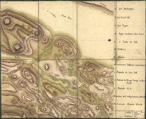
Reconnoissance des ouvrages de Ouët Point : etablis pour couvrir et assurer la communication des états du nord avec ceux du...
11645.
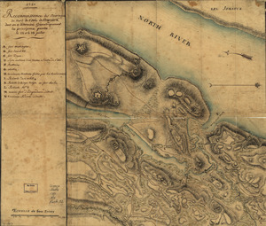
Reconnoissance des ouvrages du nord de l'Isle de Newyork dont on a déterminé géometriquement les principaux points le 22 et...
11646.
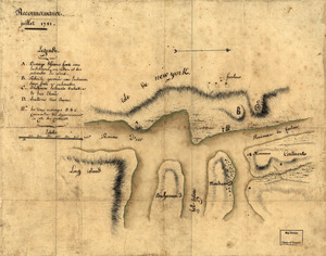
Reconnoissance, juillet 1781
11647.
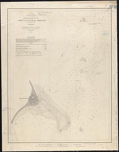
Reconnoissance of Cape Canaveral Shoals on the eastern coast of Florida
11648.
A reconnoissance of the Minnay Sotor Watapāh; or St. Peter's River to its sources : made in the year 1835
11649.
Reconnoissance of the Mississippi River below Forts Jackson and St. Philip : made previous to the reduction by the U.S. Fleet,...
11650.
Reconstruction Act, March 2, 1867, Vote on passage over President's veto
11651.
Reconstruction work in Tokyo
11652.
Recreational opportunities at Federal Energy Regulatory Commission licensed hydropower projects
11653.
Los recursos de los Estados Unidos
11654.
Red Banke
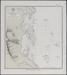
11655.
Red Sea, Safájah Island anchorages : from a British survey in 1872
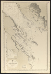
11656.
Red Sea, Strait of Jubal
11657.
Red Sea, Suez Bay : from British surveys in 1870, corrected to 1872
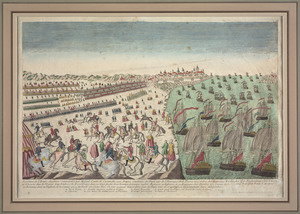
11658.
Reddition de l'armée Angloises commandée par Mylord Comte de Cornwallis aux armees combinées des Etats Unis de l'Amerique et...
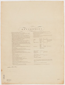
11659.
References to charts of the coast and harbors of New England
11660.
References to the plan of Gen. Gage's lines
‹ Prev
Next ›
1
2
…
579
580
581
582
583
584
585
586
587
…
708
709