Toggle navigation
LMEC Home
Exhibitions
Georeferencing
Tools for Teachers
Collections
My Favorites
Sign Up / Log In
Search
Search the map portal
Map Collection
Map Collection
Map Sets
Search
Search
Search for
Search In
All Fields
Creator
Title
Subject
Place
Search All Digital Collections
Advanced Search
1070 Results
My Search
Start Over
Back Bay Boston
Remove constraint Back Bay Boston
Filter your Search
Place
North and Central America
821
United States
521
Massachusetts
229
Suffolk (county)
176
Boston
171
Canada
115
South America
62
Asia
61
more
Place
»
Topic
Boston (Mass.)--Maps
60
City planning--Massachusetts--Boston--Maps
48
Back Bay (Boston, Mass.)--Maps
46
North America--Maps--Early works to 1800
34
Landowners--Massachusetts--Boston--Maps
26
Real property--Massachusetts--Boston--Maps
25
New England--Maps--Early works to 1800
24
Nova Scotia--Maps--Early works to 1800
24
more
Topic
»
Date
Date range begin
–
Date range end
Current results range from
1565
to
2020
View distribution
Creator
United States. Hydrographic Office
276
Des Barres, Joseph F. W. (Joseph Frederick Wallet), 1722-1824
64
Boston Redevelopment Authority
35
Jefferys, Thomas, -1771
24
Sayer, Robert, 1725-1794
24
Franke, M. (Max)
23
U.S. Lake Survey
22
United States Exploring Expedition (1838-1842)
21
more
Creator
»
Format
Maps/Atlases
1,056
Manuscripts
69
Drawings/Illustrations
10
Objects/Artifacts
3
Prints
3
Books
1
Georeferenced
Yes
54
No
1,016
Collection
Norman B. Leventhal Map & Education Center Collection
932
Maritime Charts and Atlases
477
Boston and New England Maps
258
American Revolutionary War-Era Maps
230
Urban Maps
136
Boston Redevelopment Authority Collection
54
Mapping Boston Collection
39
Library of Congress Collection
35
more
Collection
»
Available to use
No known restrictions
933
Creative Commons license
112
Search Constraints
Sort by relevance
relevance
title
date (asc)
date (desc)
Number of results to display per page
20 per page
10
per page
20
per page
50
per page
100
per page
View results as:
grid view
map view
Search Results
941.
A plat of all the world : projected according to the truest rules being far more exact than either the plain-card or the maps...
942.
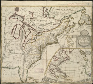
A new map of the English empire in America viz. Virginia, Maryland, Carolina, Pennsylvania, New York, New Iarsey, New England,...
943.
The River & Gulf of St. Lawrence, Newfoundland, Nova Scotia, and the banks adjacent : from the British Admiralty, French Marine...
944.
Topographical map of Westmoreland and Albert Counties : from actual surveys by D.J. Lake and H.S. Peck
945.
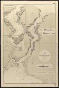
The Bosphorus : from French and British surveys in 1853, corrected to 1872
946.
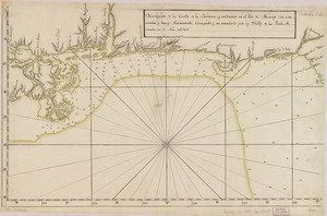
Descripción de la costa de la Luciana y entrada en el Río de Micisipi con sus sondas y bajos, nuebamente correjido y...
947.
Chart of the west coast of Sumatra between Rigas and Diah from actual survey
948.
St. Christophers
949.
Meiguo Sanfan Shi hua qiao qu : xiang xi tu = Map of San Francisco Chinatown
950.
A new map of North America : with the British, French, Spanish, Dutch & Danish dominions on that great continent, and the West...
951.
North America, east coast, Gulf of Mexico, the Gulf coast of Mexico, sheet 2 : from Tampico to Campeche Bank
952.
North Atlantic Ocean, Bermuda Islands : from the most recent Brit. Admty. surveys, 1877
953.
Le Colonie Unite dell' America Settentr'le di nuova projezione a ss. ee. li signori riformatori dello studio di Padova : con...
954.
Ierusalem, et suburbia eius, sicut tempore Christi floruit c[um] locis, in quib[us] Christ[us] pass[us] est: que religiose a...
955.
Fitz globe
956.
Dominica
957.
To the Right Honourable John Lord Sommers, Baron of Evesham in ye county of Worcester, president of Her Majesty's most...
958.
The colonies in 1660, New England and New Netherland showing extent and dates of settlement
959.
Port Mills : Port Mansfield ; Gambier Harbour
960.
The Gut of Canso : which divides ... cables distance
‹ Prev
Next ›
1
2
…
44
45
46
47
48
49
50
51
52
53
54


![Ierusalem, et suburbia eius, sicut tempore Christi floruit c[um] locis, in quib[us] Christ[us] pass[us] est: que religiose a Christianis obseruata, etiam n[um] venerationi habent](https://bpldcassets.blob.core.windows.net/derivatives/images/commonwealth:2b88qf59p/image_thumbnail_300.jpg)


