Meiguo Sanfan Shi hua qiao qu : xiang xi tu = Map of San Francisco Chinatown
Item Information
- Title:
- Meiguo Sanfan Shi hua qiao qu : xiang xi tu = Map of San Francisco Chinatown
- Description:
-
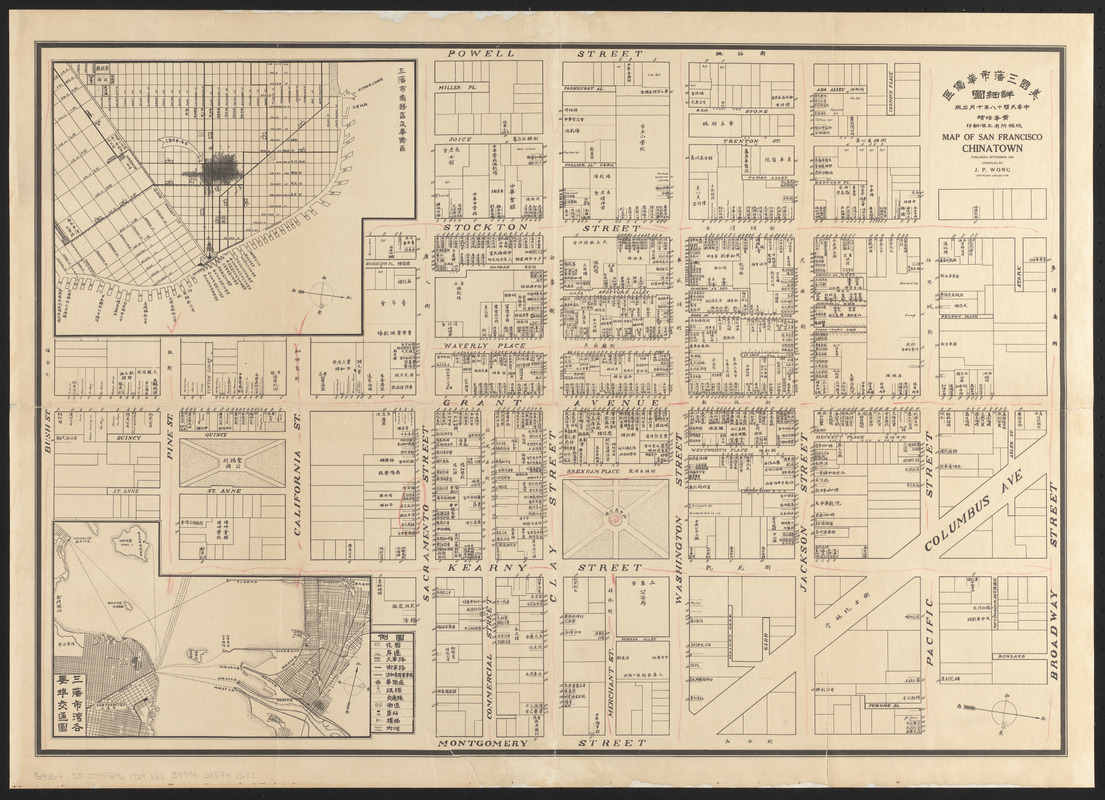
America Transformed: Many people from China and other Asian nations came to Hawaii and the West during the last half of the 19th century. Large numbers immigrated during the 1849 California Gold Rush, reaching 25,000 by 1852. During subsequent decades, they played an important role, though often exploited, as laborers for the transcontinental railroads. Prompted by racial discrimination and fears that Chinese laborers threatened American society, the 1882 Chinese Exclusion Act halted immigration from China. Many remaining immigrants created their own culturally distinct enclaves known as "Chinatowns." Displayed here is a map of San Francisco's Chinatown, the oldest and one of the largest Chinatowns in North America.
America Transformed: Viewpoint: San Francisco's Chinatown is one of the oldest continuously inhabited ethnic communities in America, but this 1929 map gives no indication of that longevity nor of its central importance to American imperial history. As much as Sinophobes repeatedly tried for decades, they could not remove Chinese from the site. It was a location in continual flux; it was a permanent residence for some, but for many it was temporary, a way station between disembarkation and destinations elsewhere. So it was for thousands of railroad workers who came to help complete the first transcontinental route in the 1860s. Even building designations were incomplete and misleading: stores could house gambling dens in the back room; laundries could be living quarters; brothels could be homes for families and children. "Chinatown" is a simple name but an extraordinarily rich and complex site of human experiences. –Gordon H. Chang, Professor of History, Olive H. Palmer Professor in Humanities, and Senior Associate Vice Provost for Undergraduate Education, Stanford University
- Cartographer:
- Wong, J. P.
- Name on Item:
-
Huang Huapei hui = compiled by J.P. Wong
- Date:
-
1929
- Format:
-
Maps/Atlases
- Location:
-
Boston Public Library
Norman B. Leventhal Map & Education Center - Collection (local):
-
Norman B. Leventhal Map & Education Center Collection
- Subjects:
-
Real property--California--San Francisco--Maps
Chinatown (San Francisco, Calif.)--Maps
- Places:
-
CaliforniaSan Francisco (county)San FranciscoChinatown
- Extent:
- 1 map ; 47 x 67 cm
- Terms of Use:
-
No known copyright restrictions.
No known restrictions on use.
- Publisher:
-
[San Francisco?] :
J.P. Wong
- Scale:
-
Scale approximately 1:1,200
- Language:
-
Chinese
English
- Notes:
-
Lithograph map with 2 insets, showing the extent of Chinatown in San Francisco and, in the second inset map, the extent of Oakland's Chinatown. It is the first map made by Chinese Americans of San Francisco for the Chinese community. The map depicts the largest Chinatown in North America during the Roaring '20s, an especially dramatic period in the neighborhood's history. It shows city blocks and building lots, each with appropriate street address numbers. The map was made for the Benevolent Association also known as the Chinese Six companies formed in 1882. The map is horizontally centered on Grant Street the heart of the neighborhood, bordered by Bush Street, Broadway Street on the north, Powell Street on the west, and Montgomery Street on the east.
From the family of Mr. H. Wong, Boston Chinatown.
Published September,1929.
Oriented with north to the right.
Inset maps: Sanfan Shi shang wu qu ji hua qiao qu ; Sanfan Shi wan ge yao bu jiao tong tu.
Includes insets of San Francisco business district and San Francisco Bay showing port traffic.
Chinese and English. Street names in English, business and place names in Chinese.
- Notes (exhibitions):
-
Exhibited: "America Transformed. Part 2: Homesteads to Modern Cities," organized by the Norman B. Leventhal Map & Education Center at the Boston Public Library, 2019-2020.
- Identifier:
-
06_01_016079
- Call #:
-
G4364.S5:2C45G46 1929 .W66
- Barcode:
-
39999085942637


