Toggle navigation
LMEC Home
Exhibitions
Georeferencing
Tools for Teachers
Collections
My Favorites
Sign Up / Log In
Search
Search the map portal
Map Collection
Map Collection
Map Sets
Search
Search
Search for
Search In
All Fields
Creator
Title
Subject
Place
Search All Digital Collections
Advanced Search
111 Results
My Search
Start Over
new brunswick
Remove constraint new brunswick
Filter your Search
Place
North and Central America
103
Canada
82
Province of New Brunswick
51
United States
42
Maine
17
Nova Scotia
12
New England
9
Saint John
9
more
Place
»
Topic
New Brunswick--Maps
11
Maine--Maps
8
New England--Maps
7
Canada--Boundaries--United States--Maps
6
Coasts--New Brunswick--Maps
6
Fort Cumberland (N.B.)--Maps, Manuscript--Early works to 1800
6
New Brunswick--Maps--Early works to 1800
6
Nova Scotia--Maps
6
more
Topic
»
Date
Date range begin
–
Date range end
Current results range from
1662
to
1992
View distribution
Creator
Amherst, Jeffery Amherst, Baron, 1717-1797
9
Royal United Services Institute for Defence and Security Studies
9
Des Barres, Joseph F. W. (Joseph Frederick Wallet), 1722-1824
8
George, III, King of Great Britain, 1738-1820
8
George, IV, King of Great Britain, 1762-1830
8
Bruce, Robert George
7
Parr, John, 1725-1791
6
United States. Hydrographic Office
6
more
Creator
»
Format
Maps/Atlases
111
Manuscripts
16
Objects/Artifacts
1
Georeferenced
Yes
5
No
106
Collection
Norman B. Leventhal Map & Education Center Collection
61
American Revolutionary War-Era Maps
58
British Library Collection
17
Boston and New England Maps
14
Maritime Charts and Atlases
11
Library of Congress Collection
10
Urban Maps
10
William L. Clements Library Collection
9
more
Collection
»
Available to use
No known restrictions
60
Creative Commons license
33
Search Constraints
Sort by relevance
relevance
title
date (asc)
date (desc)
Number of results to display per page
20 per page
10
per page
20
per page
50
per page
100
per page
View results as:
grid view
map view
Search Results
61.
Map of the disputed territory,with a full description
62.
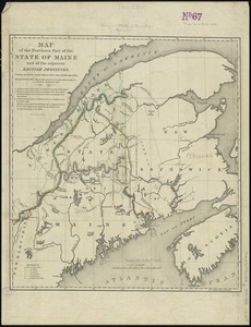
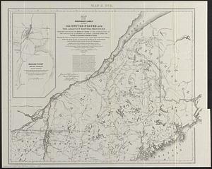
Map of the northern part of the state of Maine and of the adjacent British provinces : shewing the portion of that state to...
63.
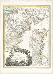
The United States of America laid down from the best authorities, agreeable to the Peace of 1783
64.
PLAN and SECTIONS of Cumberland Hill Showing the Situation of FORT CUMBERLAND Upon the Isthmus of NOVA SCOTIA
65.
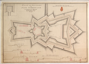
PLAN and SECTIONS of FORT CUMBERLAND As Proposed to be Repaired
66.
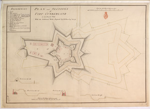
PLAN and SECTIONS of FORT CUMBERLAND in its Present State With the Additional Works Proposed
67.
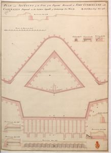
PLAN and SECTIONS of the Front of the Projected Hornwork at FORT CUMBERLAND with CASEMATES Proposed in the Curtain Capable of...
68.
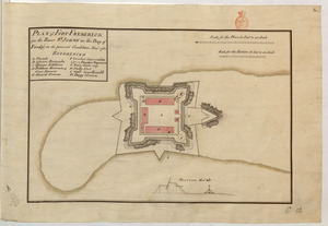
PLAN of FORT FREDERICK (in the River S.T JOHNS in the Bay of Fundy) in its present condition Nov.r 1761
69.
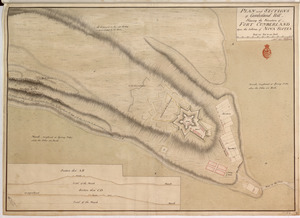
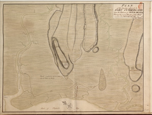
PLAN of the Country adjacent to FORT CUMBERLAND Upon the Isthmus of NOVA-SCOTIA Showing the general Situation of that Fort
70.
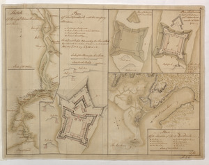
Plan of the Harbour of St John's in the Bay of Fundy= Plan & Section of the Fort as it is Near Finish'd= Plan & Section's of...
71.
Sketch Of Part of S.t John's Harbour and River= Plan of Fort Frederick with the Necessary Alterations= Plan of the Ramainder of...
72.
Map of the boundary lines between the United States and the adjacent British provinces from the mouth of the River St. Croix to...
73.
A map & chart of the bays harbours post roads and settlements in Passamaquoddy & Machias with the large island of Grand Manan
74.
A sketch of part of the river St. John on the north side of the Bay of Fundy from Partridge Island in the latitude of 45.22...
75.
A chart of the North-American coast, for the navigation between Halifax and Philadelphia
76.
Miramichi Bay
77.
Carte du theatre de la guerre presente en Amerique
78.
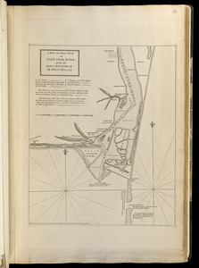
A new and exact plan of Cape Fear River, from the bar to Brunswick
79.
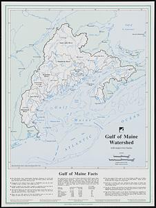
Gulf of Maine watershed : with major river basins
80.
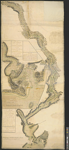
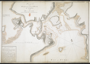
PLAN of the HARBOUR and Part of the RIVER S.T JOHNS in the BAY of FUNDY
‹ Prev
Next ›
1
2
3
4
5
6