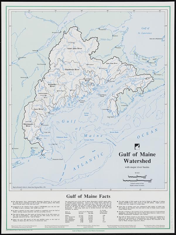
Gulf of Maine watershed : with major river basins
Item Information
- Title:
- Gulf of Maine watershed : with major river basins
- Cartographer:
- Kelly, Richard D.
- Issuing body:
- Gulf of Maine Council on the Marine Environment
- Name on Item:
-
map by Richard D. Kelly, Jr., Maine State Planning Office, 1991 ; poster by Richard D. Kelly, Jr., Maine State Planning Office, 1992
- Date:
-
[1992]
- Format:
-
Maps/Atlases
- Location:
-
Boston Public Library
Norman B. Leventhal Map & Education Center - Collection (local):
-
David Judkins Weaver Papers
- Subjects:
-
Maine, Gulf of--Maps
Watersheds--Maine--Maps
Watersheds--New Hampshire--Maps
Watersheds--New Brunswick--Maps
Watersheds--Massachusetts--Maps
Watersheds--Nova Scotia--Maps
- Places:
-
Maine, Gulf of
- Extent:
- 1 map : color ; 47 x 41 cm, on sheet 61 x 46 cm
- Terms of Use:
-
No known copyright restrictions.
No known restrictions on use.
- Publisher:
-
[Augusta, Maine] :
Gulf of Maine Council on the Marine Environment
- Scale:
-
Scale approximately 1:2,150,000
- Language:
-
English
- Notes:
-
Relief shown by contours. Depths shown by isolines.
Includes text and land area data by state and province.
- Notes (date):
-
This date is inferred.
- Identifier:
-
06_01_018807
- Call #:
-
Weaver folder 15 no. 4


