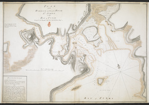
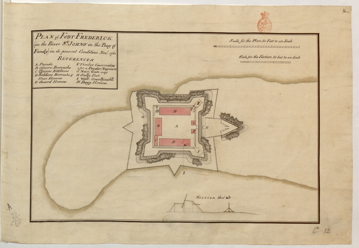
PLAN of FORT FREDERICK (in the River S.T JOHNS in the Bay of Fundy) in its present condition Nov.r 1761
This map is also available in American Revolutionary Geographies Online (ARGO), a collections portal especially built for material relating to the American Revolutionary War Era. Visit ARGO to learn more about this item and explore the historical geography of North America in the late eighteenth century.
Item Information
- Title:
- PLAN of FORT FREDERICK (in the River S.T JOHNS in the Bay of Fundy) in its present condition Nov.r 1761
- Cartographer:
- Bruce, Robert George
- Former owner:
- Amherst, Jeffery Amherst, Baron, 1717-1797
- Former owner:
- Royal United Services Institute for Defence and Security Studies
- Date:
-
1761
- Format:
-
Maps/Atlases
- Location:
- British Library
- Collection (local):
-
British Library Collection
- Subjects:
-
Fortification--New Brunswick--Saint John--Maps, Manuscript--Early works to 1800
Military art and science--New Brunswick--Saint John--Maps, Manuscript--Early works to 1800
Saint John (N.B.)--Maps, Manuscript--Early works to 1800
- Places:
-
CanadaSaint John
- Extent:
- 1 map : manuscript pen and ink with watercolour ; 29 x 44 cm
- Terms of Use:
-
No known copyright restrictions.
This work is licensed for use under a Creative Commons Attribution Non-Commercial Share Alike License (CC BY-NC-SA).

- Publisher:
-
[Fort Frederick?] :
[Robert George Bruce]
- Scale:
-
Scale approximately 1:720
- Language:
-
English
- Catalog Record:
-
http://searcharchives.bl.uk/IAMS_VU2:IAMS040-001999732
- Notes:
-
Cartographer/producer attributed on comparison with other maps in the R.U.S.I. signed "R G Bruce" (see Add Ms 57,701.9 / Add Ms 57,701.10 / Add Ms 57,701.11 / Add Ms 57,701.12.).
Shows title in surround at upper right including lettered key (A-K) identifying locations within the fort.
Shows "Sc ale for the Plan, 60 Feet to an Inch" and "Scale for the Section 20 Feet to an Inch" at upper right.
Shows a sectional view through the fort at lower centre (scale approximately 1:240).
Copy at Add Ms 57,702.16. Bound in R.U.S.I. Vol LXVII. Shows red stamp of R.U.S.I. in margin at upper right. Shows manuscript addition of "16 02" in pencil at upper right. Shows manuscript addition of "A 28/68" in pencil at lower left. Shows manuscript addition of "C 12" in pencil at lower right. Laid on archival tissue. Green circular label to verso showing "11". White label to verso showing "DRAWER 28 SECTION 1". Blue label to verso shows "A 28/68".
- Notes (date):
-
9999