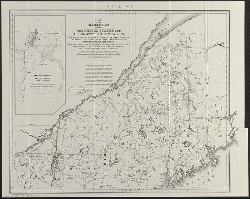
Map of the boundary lines between the United States and the adjacent British provinces from the mouth of the River St. Croix to the intersection of the parallel of 45 degrees of north latitude with the River St. Lawrence near St. Regis showing the lines as respectively claimed by the United States and Great Britain under the treaty of 1783, as awarded by the King of the Netherlands and as settled in 1842 by the Treaty of Washington
Item Information
- Title:
- Map of the boundary lines between the United States and the adjacent British provinces from the mouth of the River St. Croix to the intersection of the parallel of 45 degrees of north latitude with the River St. Lawrence near St. Regis showing the lines as respectively claimed by the United States and Great Britain under the treaty of 1783, as awarded by the King of the Netherlands and as settled in 1842 by the Treaty of Washington
- Cartographer:
- United States. Army. Corps of Topographical Engineers
- Cartographer:
- Graham, J. D. (James Duncan), 1799-1865
- Contributor:
- Moore, John Bassett, 1860-1947
- Contributor:
- United States. Congress (53rd, 2nd session : 1893-1894). House
- Name on Item:
-
compiled by Lieut. T.J. Lee, Topl. Engineers and W.M.C. Fairfax, civil engr. under the direction of Major J.D. Graham, Corps of Topographical Engrs
- Date:
-
[1898]
- Format:
-
Maps/Atlases
- Location:
-
Boston Public Library
Norman B. Leventhal Map & Education Center - Collection (local):
-
Norman B. Leventhal Map & Education Center Collection
- Subjects:
-
Northeast boundary of the United States--Maps
United States--Boundaries--Canada--Maps
Canada--Boundaries--United States--Maps
- Places:
-
Maine
CanadaQuebec (province)
CanadaProvince of New Brunswick (province)
- Extent:
- 1 map ; 54 x 69 cm
- Terms of Use:
-
No known copyright restrictions.
No known restrictions on use.
- Publisher:
-
[Washington] :
[Government Printing Office]
- Scale:
-
Scale approximately 1:1,050,000
- Language:
-
English
- Notes:
-
Inset: Rouse's Point and its vicinity on Lake Champlain.
In upper margin: Map G no. 3.
Printed signature of James D. Graham, Major Topl. Engineers Commissioner.
Detached from House of Representatives 53d congress, 2d session, mis. doc. no. 212. History and digest of the international arbitrations to which the United States has been a party volume I (Washington : Government Printing Office, 1898).
- Notes (date):
-
This date is inferred.
- Identifier:
-
06_01_018398
- Call #:
-
G3701.F2 1898 .U5
- Barcode:
-
39999085966891
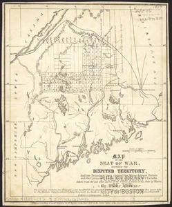
![Map of the disputed territory [Maine]](https://bpldcassets.blob.core.windows.net/derivatives/images/commonwealth:7h14b025h/image_thumbnail_300.jpg)