Toggle navigation
LMEC Home
Exhibitions
Georeferencing
Tools for Teachers
Collections
My Favorites
Sign Up / Log In
Search
Search the map portal
Map Collection
Map Collection
Map Sets
Search
Search
Search for
Search In
All Fields
Creator
Title
Subject
Place
Search All Digital Collections
Advanced Search
972 Results
My Search
Start Over
More Like
commonwealth-oai:wd379s939
Remove constraint More Like: commonwealth-oai:wd379s939
Filter your Search
Place
North and Central America
943
United States
682
New York
227
Canada
205
Quebec
111
Pennsylvania
61
New Jersey
59
Manhattan
49
more
Place
»
Topic
United States--History--Revolution, 1775-1783--Maps
330
United States--History--French and Indian War, 1754-1763--Maps
149
Manhattan (New York, N.Y.)--Maps
51
Saint Lawrence River--Maps
43
Newport (R.I.)--Maps
27
New York (N.Y.)--Maps
26
New York (State)--Maps
24
Hudson River (N.Y. and N.J.)--Maps
21
more
Topic
»
Date
Date range begin
–
Date range end
Current results range from
1700
to
1939
View distribution
Creator
Rocque, Mary Ann
29
Holland, Samuel, 1728-1801
25
Jefferys, Thomas, -1771
25
Montrésor, John, 1736-1799
25
Bellin, Jacques Nicolas, 1703-1772
24
Clinton, Henry, Sir, 1738?-1795
19
Robert Sayer and John Bennett (Firm)
16
Hills, John, active 1777-1819
13
more
Creator
»
Format
Maps/Atlases
956
Drawings/Illustrations
11
Documents
5
Manuscripts
5
Prints
1
Georeferenced
Yes
10
No
962
Collection
American Revolutionary War-Era Maps
931
William L. Clements Library Collection
909
Norman B. Leventhal Map & Education Center Collection
42
Urban Maps
26
American Antiquarian Society Collection
7
Boston and New England Maps
5
New-York Historical Society Collection
4
Newberry Library Collection
3
more
Collection
»
Available to use
No known restrictions
46
Creative Commons license
5
Search Constraints
Sort by relevance
relevance
title
date (asc)
date (desc)
Number of results to display per page
20 per page
10
per page
20
per page
50
per page
100
per page
View results as:
grid view
map view
Search Results
701.
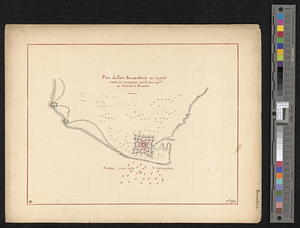
Plan and project, for fortifying the high commanding ground at the church of Deschambeaux as also the island of Richlieu [sic]
702.
A plan and section of the two routs in Woburn, say 1795 : Middlesex Canal
703.
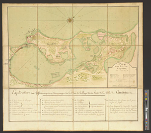
Plan de la baye de Cartagene dans l'Amérique
704.
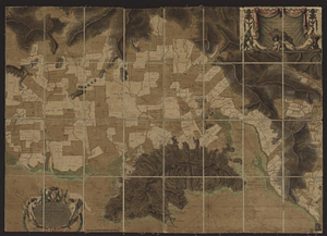
Plan de la plaine du Cap François en l'Isle St. Domingue : redigé d'après les dernières opérations géometriques des ingénieurs...
705.
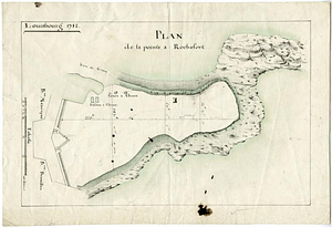
Plan de la pointe à Rochefort
706.
Plan de la rivière d'Albanie dans la baye de Hudson
707.
Plan de la rivière de Serraleone depuis son embouchûre jusqu'à l'ile de Banse : corrigé d'aprés celui de Smith, sur les...
708.
Plan de la rivière Slude
709.
Plan de la ville de Boston et ses environs
710.
Plan de la ville de Louisbourg à l'Isle Royale
711.
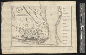
Plan de la ville de Québec
712.
Plan de l'attaque de Porto Bello par l'Amiral Vernon
713.
Plan de l'Habitation de Monsieur de La Porte-Lalanne Située au Quartier du Cul-de-Sac Dépendence du Port-au-Prince : en l'Etat...
714.
Plan de l'habitation de Sr. Fleuriau depuis 1743 qu'il a commencé a l'établir, jusq'en 1749 ... suivant le nouveau plan tiré...
715.
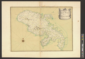
Plan de l'Isle de Martinique
716.
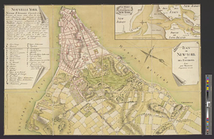
Plan de New-York et des environs
717.
Plan du Fort Boccachica qui deffend l'entrée de Cartagene sur la cote septle de l'isthme de Panama
718.
Plan du fort de Carillon et de ses environs avec l'attaque des retranchments faite par une armee Angloise de 25000 homes aux...
719.
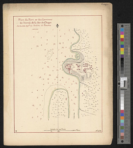
Plan du fort et des environs de l'entrée de la riv. de Chagre sur la cote septle de l'isthme de Panama
720.
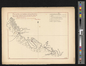
Plan du port de Calidone et de ses environs dans le Golfe de Darien et sur la cote septle de l'isthme de Panama
‹ Prev
Next ›
1
2
…
32
33
34
35
36
37
38
39
40
…
48
49
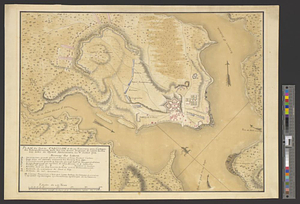
![Plan and project, for fortifying the high commanding ground at the church of Deschambeaux as also the island of Richlieu [sic]](https://bpldcassets.blob.core.windows.net/derivatives/metadata/commonwealth-oai:pz50mt24s/image_thumbnail_300.jpg)