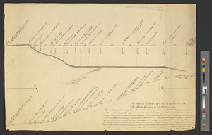
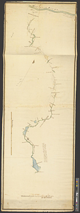
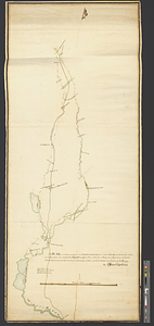
A plan and section of the two routs in Woburn, say 1795 : Middlesex Canal
This map is also available in American Revolutionary Geographies Online (ARGO), a collections portal especially built for material relating to the American Revolutionary War Era. Visit ARGO to learn more about this item and explore the historical geography of North America in the late eighteenth century.
Item Information
- Title:
- A plan and section of the two routs in Woburn, say 1795 : Middlesex Canal
- Creator:
- Baldwin, Loammi, 1745-1807
- Date:
-
1795
- Format:
-
Maps/Atlases
- Genre:
-
Manuscript maps
- Location:
- William L. Clements Library
- Collection (local):
-
William L. Clements Library Collection
- Subjects:
-
Canals--Massachusetts--Maps
Middlesex Canal (Mass.)--Maps
Woburn (Mass.)--Maps
- Places:
-
MassachusettsMiddlesex (county)Middlesex Canal
MassachusettsMiddlesex (county)Woburn
- Extent:
- 1 ms. map on 2 sheets : col. ; 53 x 148 cm.
- Terms of Use:
-
The University of Michigan Library provides access to these materials for educational and research purposes. These materials may be under copyright. If you decide to use any of these materials, you are responsible for making your own legal assessment and securing any necessary permission. If you have questions about the collection, please contact the William L. Clements Library.
Contact host institution for more information.
- Scale:
-
Scale 1:15,840.
- Language:
-
English
- Catalog Record:
-
Catalog record
- Notes:
-
Finished, pen and ink profile of the route described.
Title and author from verso.
- Identifier:
-
8762
- Barcode:
-
B3654611