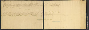
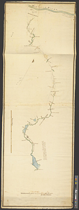
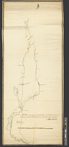
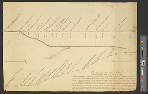
A plan & section of a survey taken April 20, 1801 on a new prepared course for the Middlesex Canal, from the south end of Richey and Mohaneys job in Polly Carters field, extinding southerly upon the land on the east side of Horn Pond in Woburn to unite with the old work at the north side of the Paul Wymans Howard pasture at the sluce way west of Simpson's Mill, so calld, in Woburn ...
This map is also available in American Revolutionary Geographies Online (ARGO), a collections portal especially built for material relating to the American Revolutionary War Era. Visit ARGO to learn more about this item and explore the historical geography of North America in the late eighteenth century.
Item Information
- Title:
- A plan & section of a survey taken April 20, 1801 on a new prepared course for the Middlesex Canal, from the south end of Richey and Mohaneys job in Polly Carters field, extinding southerly upon the land on the east side of Horn Pond in Woburn to unite with the old work at the north side of the Paul Wymans Howard pasture at the sluce way west of Simpson's Mill, so calld, in Woburn ...
- Creator:
- Baldwin, Loammi, 1745-1807
- Name on Item:
-
Loammi Baldwin
- Date:
-
1801
- Format:
-
Maps/Atlases
- Genre:
-
Manuscript maps
- Location:
- William L. Clements Library
- Collection (local):
-
William L. Clements Library Collection
- Subjects:
-
Canals--Massachusetts--Maps
Middlesex Canal (Mass.)--Maps
Woburn (Mass.)--Maps
- Places:
-
MassachusettsMiddlesex (county)Middlesex Canal
MassachusettsMiddlesex (county)Woburn
- Extent:
- 1 ms. map ; 38.2 x 54.6 cm.
- Terms of Use:
-
The University of Michigan Library provides access to these materials for educational and research purposes. These materials may be under copyright. If you decide to use any of these materials, you are responsible for making your own legal assessment and securing any necessary permission. If you have questions about the collection, please contact the William L. Clements Library.
Contact host institution for more information.
- Scale:
-
Scale 1:3,960.
- Language:
-
English
- Catalog Record:
-
Catalog record
- Notes:
-
Finished, pen and ink profile.
- Identifier:
-
8760
- Barcode:
-
B3654636