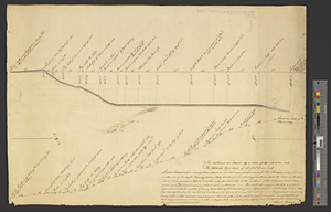
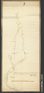
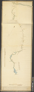
Middlesex Canal : copy'd from the survey of Mr. Thompson
This map is also available in American Revolutionary Geographies Online (ARGO), a collections portal especially built for material relating to the American Revolutionary War Era. Visit ARGO to learn more about this item and explore the historical geography of North America in the late eighteenth century.
Item Information
- Title:
- Middlesex Canal : copy'd from the survey of Mr. Thompson
- Contributor:
- Carleton, Osgood, 1742-1816
- Creator:
- Thompson, Samuel, surveyor
- Name on Item:
-
by Osgood Carleton
- Date:
-
[1795]
- Format:
-
Maps/Atlases
- Genre:
-
Manuscript maps
- Location:
- William L. Clements Library
- Collection (local):
-
William L. Clements Library Collection
- Subjects:
-
Middlesex Canal (Mass.)--Maps
Canals--Massachusetts--Maps
- Places:
-
MassachusettsMiddlesex (county)Middlesex Canal
- Extent:
- 1 ms. map : col. ; 147.2 x 52.9 cm.
- Terms of Use:
-
The University of Michigan Library provides access to these materials for educational and research purposes. These materials may be under copyright. If you decide to use any of these materials, you are responsible for making your own legal assessment and securing any necessary permission. If you have questions about the collection, please contact the William L. Clements Library.
Contact host institution for more information.
- Scale:
-
Scale 1:32,000.
- Language:
-
English
- Catalog Record:
-
Catalog record
- Notes:
-
Finished, colored map showing the course of the canal between the Mystic and Merrimack rivers, identifying natural features, roads, and buildings along the route.
A note on the verso reads: Trunk B. Thompson first survey for M Canal drawn by Carlton.
- Notes (date):
-
This date is inferred.
- Identifier:
-
8714
- Barcode:
-
B2856185