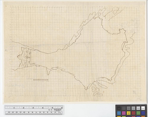
Plan de la ville de Boston et ses environs

This map is also available in American Revolutionary Geographies Online (ARGO), a collections portal especially built for material relating to the American Revolutionary War Era. Visit ARGO to learn more about this item and explore the historical geography of North America in the late eighteenth century.
Item Information
- Title:
- Plan de la ville de Boston et ses environs
- Creator:
- Bellin, Jacques Nicolas, 1703-1772
- Date:
-
[ca. 1755]
- Format:
-
Maps/Atlases
- Location:
- William L. Clements Library
- Collection (local):
-
William L. Clements Library Collection
- Subjects:
-
Boston (Mass.)--Maps
- Places:
-
MassachusettsSuffolk (county)Boston
- Extent:
- 1 map : colored ; 16.4 x 28 cm
- Terms of Use:
-
The University of Michigan Library provides access to these materials for educational and research purposes. These materials may be under copyright. If you decide to use any of these materials, you are responsible for making your own legal assessment and securing any necessary permission. If you have questions about the collection, please contact the William L. Clements Library.
Contact host institution for more information.
- Publisher:
-
[Paris?] :
[Didot?]
- Scale:
-
Scale approximately 1:48,440.
- Language:
-
French
- Catalog Record:
-
Catalog record
- Notes:
-
Relief shown pictorially and by hachures.
Shows street plan of Boston and Charles Town.
Includes table of reference in left margin.
Probably from: Prévost, abbé. Histoire générale des voyages ... . Paris, ca. 1755.
- Identifier:
-
5521
- Barcode:
-
B8502694