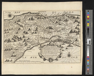
Plan du port de Calidone et de ses environs dans le Golfe de Darien et sur la cote septle de l'isthme de Panama
This map is also available in American Revolutionary Geographies Online (ARGO), a collections portal especially built for material relating to the American Revolutionary War Era. Visit ARGO to learn more about this item and explore the historical geography of North America in the late eighteenth century.
Item Information
- Title:
- Plan du port de Calidone et de ses environs dans le Golfe de Darien et sur la cote septle de l'isthme de Panama
- Creator:
- Buache, Philippe, 1700-1773
- Date:
-
[ca. 1750]
- Format:
-
Maps/Atlases
- Genre:
-
Manuscript maps
- Location:
- William L. Clements Library
- Collection (local):
-
William L. Clements Library Collection
- Subjects:
-
Darien (Panama and Colombia)--Maps
Panama--Maps
- Places:
-
Darién (region)
Panama
- Extent:
- 1 ms. map : outline col. ; 18 x 24 cm.
- Terms of Use:
-
The University of Michigan Library provides access to these materials for educational and research purposes. These materials may be under copyright. If you decide to use any of these materials, you are responsible for making your own legal assessment and securing any necessary permission. If you have questions about the collection, please contact the William L. Clements Library.
Contact host institution for more information.
- Scale:
-
Scale of French leagues.
- Language:
-
French
- Catalog Record:
-
Catalog record
- Notes:
-
Finished pen and ink topographical map showing Scottish settlement on the Gulf of Darien in 1700 and positions of Spanish forces sent to expel them.
Initialed at lower left: PB.
Appears to be a page (no. 355) of a manuscript atlas.
Table of references identifies major features and positions of the siege.
- Identifier:
-
5503
- Barcode:
-
B4277466