Carte de l'isthme de Panama depuis Panama jusques à la rivière de Nata du coté du sud, et depuis Porto Bello, jusques à la rivière de Cocle du coté du nord, avec tous les bourgs et villes, rivières, montagnes, et lieux les plus considerables, exactement dessinez sur les lieux
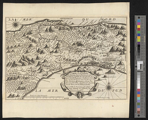
This map is also available in American Revolutionary Geographies Online (ARGO), a collections portal especially built for material relating to the American Revolutionary War Era. Visit ARGO to learn more about this item and explore the historical geography of North America in the late eighteenth century.
Item Information
- Title:
- Carte de l'isthme de Panama depuis Panama jusques à la rivière de Nata du coté du sud, et depuis Porto Bello, jusques à la rivière de Cocle du coté du nord, avec tous les bourgs et villes, rivières, montagnes, et lieux les plus considerables, exactement dessinez sur les lieux
- Creator:
- Exquemelin, A. O. (Alexandre Olivier)
- Name on Item:
-
par A.O. Exquemelin ... 1686
- Date:
-
[1744]
- Format:
-
Maps/Atlases
- Location:
- William L. Clements Library
- Collection (local):
-
William L. Clements Library Collection
- Subjects:
-
Panama--Maps
- Places:
-
Panama
- Extent:
- 1 map ; 19.3 x 29 cm
- Terms of Use:
-
The University of Michigan Library provides access to these materials for educational and research purposes. These materials may be under copyright. If you decide to use any of these materials, you are responsible for making your own legal assessment and securing any necessary permission. If you have questions about the collection, please contact the William L. Clements Library.
Contact host institution for more information.
- Place of origin:
-
[Trevoux]
- Scale:
-
Scale in Spanish leagues.
- Language:
-
French
- Catalog Record:
-
Catalog record
- Notes:
-
From same plate as copy in Exquemelin, A.O. Histoire des avanturiers ..., 1744 but lacks volume and page information and numeral 8 at lower right.
- Notes (date):
-
This date is inferred.
- Identifier:
-
5458
- Barcode:
-
B1940182
 IIIF Manifest