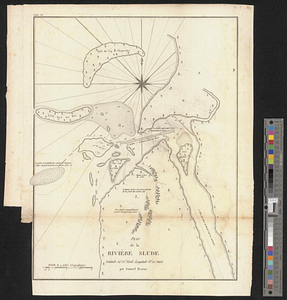
Plan de la rivière Slude
This map is also available in American Revolutionary Geographies Online (ARGO), a collections portal especially built for material relating to the American Revolutionary War Era. Visit ARGO to learn more about this item and explore the historical geography of North America in the late eighteenth century.
Item Information
- Title:
- Plan de la rivière Slude
- Creator:
- Hearne, Samuel, 1745-1792
- Name on Item:
-
par Samuel Hearne
- Date:
-
[1799]
- Format:
-
Maps/Atlases
- Location:
- William L. Clements Library
- Collection (local):
-
William L. Clements Library Collection
- Subjects:
-
Rupert River (Québec)--Maps
- Places:
-
CanadaQuebec (province)Rupert, Rivière de (river)
- Extent:
- 1 map ; 35.6 x 28.2 cm.
- Terms of Use:
-
The University of Michigan Library provides access to these materials for educational and research purposes. These materials may be under copyright. If you decide to use any of these materials, you are responsible for making your own legal assessment and securing any necessary permission. If you have questions about the collection, please contact the William L. Clements Library.
Contact host institution for more information.
- Place of origin:
-
[Paris]
- Scale:
-
Scale 1:110,000.
- Language:
-
French
- Catalog Record:
-
Catalog record
- Notes:
-
Shows mouth of Rupert River at James Bay.
- Notes (date):
-
This date is inferred.
- Identifier:
-
6291
- Barcode:
-
B3665536


