Toggle navigation
LMEC Home
Exhibitions
Georeferencing
Tools for Teachers
Collections
My Favorites
Sign Up / Log In
Search
Search the map portal
Map Collection
Map Collection
Map Sets
Search
Search
Search for
Search In
All Fields
Creator
Title
Subject
Place
Search All Digital Collections
Advanced Search
985 Results
My Search
Start Over
More Like
commonwealth-oai:rv046r891
Remove constraint More Like: commonwealth-oai:rv046r891
Filter your Search
Place
North and Central America
957
United States
690
Canada
206
New York
201
Quebec
112
Pennsylvania
91
New Jersey
79
Nova Scotia
48
more
Place
»
Topic
United States--History--Revolution, 1775-1783--Maps
330
United States--History--French and Indian War, 1754-1763--Maps
149
Pennsylvania--Maps
50
Saint Lawrence River--Maps
43
New Jersey--Maps
40
New York (State)--Maps
34
Newport (R.I.)--Maps
27
Hudson River (N.Y. and N.J.)--Maps
22
more
Topic
»
Date
Date range begin
–
Date range end
Current results range from
1700
to
1921
View distribution
Creator
Rocque, Mary Ann
29
Holland, Samuel, 1728-1801
26
Bellin, Jacques Nicolas, 1703-1772
25
Jefferys, Thomas, -1771
25
Montrésor, John, 1736-1799
25
Clinton, Henry, Sir, 1738?-1795
19
Robert Sayer and John Bennett (Firm)
16
Hills, John, active 1777-1819
13
more
Creator
»
Format
Maps/Atlases
969
Drawings/Illustrations
11
Documents
5
Manuscripts
5
Prints
1
Georeferenced
Yes
20
No
965
Collection
American Revolutionary War-Era Maps
943
William L. Clements Library Collection
909
Norman B. Leventhal Map & Education Center Collection
47
American Antiquarian Society Collection
13
Boston and New England Maps
5
MacLean Collection Map Library
5
Urban Maps
4
Newberry Library Collection
3
more
Collection
»
Available to use
No known restrictions
49
Creative Commons license
5
Search Constraints
Sort by relevance
relevance
title
date (asc)
date (desc)
Number of results to display per page
20 per page
10
per page
20
per page
50
per page
100
per page
View results as:
grid view
map view
Search Results
801.
Plan of the battle and situation of the British and French armys on the Heights of Abraham the 28th: of April 1760 : repetition...
802.
Plan of the battle fought the 28th of April 1760 upon the Height of Abraham near Quebec between the British troops garrisoned...
803.
Plan of the camp and battle of Alamance the 16 May 1771 between the provincials of Nth: Carolina, commanded by his excellency...
804.
A plan of the city & fortifications of Louisbourg
805.
A plan of the city & fortifications of Louisbourg
806.
A plan of the city & harbor of Louisburg
807.
Plan of the city & harbour of Havanna, capital of Cuba
808.
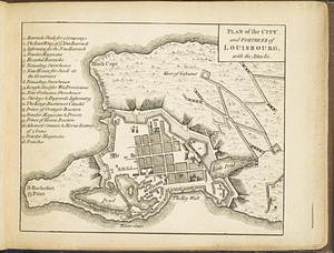
Plan of the city and fortress of Louisbourg, with the attacks
809.
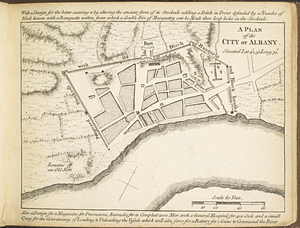
A plan of the city of Albany situated lat. 42, 30" long. 74
810.
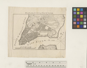
Plan of the city of New York
811.
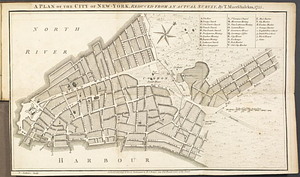
A plan of the city of New-York, reduced from an actual survey
812.
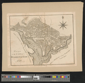
Plan of the city of Washington
813.
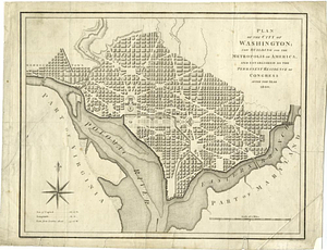
Plan of the city of Washington; now building for the metropolis of America, and established as the permanent residence of...
814.
A plan of the coast of Newfoundland from Cape Bonavista to Cape Chapeau Rouge wherein seven-eights of the fishery of the island...
815.
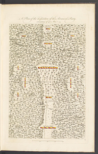
A plan of the disposition of the advanced party, consisting of 400 men
816.
Plan of the encampment, intrenchment with theier [sic] environs at Lake George
817.
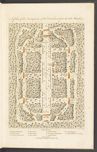
A plan of the encampment of the detachment from the Little Meadows
818.
A plan of the entervale [sic] and hundred acre lotts in the township of Piermont
819.
Plan of the entrance of the Harbour of Pensacola shewing the situation of the new battery's laid out and begun building in...
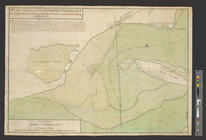
820.
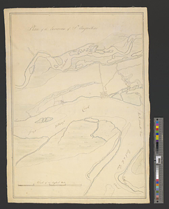
Plan of the environs of St. Augustine
‹ Prev
Next ›
1
2
…
37
38
39
40
41
42
43
44
45
…
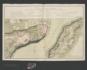
49
50
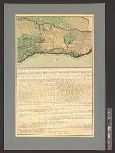

![A plan of the coast of Newfoundland from Cape Bonavista to Cape Chapeau Rouge wherein seven-eights of the fishery of the island is caried [sic] on](https://bpldcassets.blob.core.windows.net/derivatives/metadata/commonwealth-oai:cz30tq534/image_thumbnail_300.jpg)
![Plan of the encampment, intrenchment with theier [sic] environs at Lake George](https://bpldcassets.blob.core.windows.net/derivatives/metadata/commonwealth-oai:v9800134b/image_thumbnail_300.jpg)
![A plan of the entervale [sic] and hundred acre lotts in the township of Piermont](https://bpldcassets.blob.core.windows.net/derivatives/metadata/commonwealth-oai:02874t092/image_thumbnail_300.jpg)