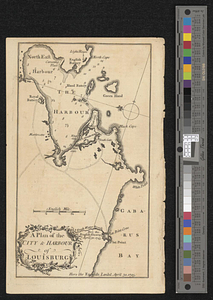
A plan of the city & harbor of Louisburg
This map is also available in American Revolutionary Geographies Online (ARGO), a collections portal especially built for material relating to the American Revolutionary War Era. Visit ARGO to learn more about this item and explore the historical geography of North America in the late eighteenth century.
Item Information
- Title:
- A plan of the city & harbor of Louisburg
- Date:
-
[1758]
- Format:
-
Maps/Atlases
- Location:
- William L. Clements Library
- Collection (local):
-
William L. Clements Library Collection
- Subjects:
-
Louisbourg (N.S.)--Maps
United States--History--French and Indian War, 1754-1763--Maps
- Places:
-
CanadaNova Scotia (province)Louisbourg
- Extent:
- 1 map ; 19.7 x 11.3 cm.
- Terms of Use:
-
The University of Michigan Library provides access to these materials for educational and research purposes. These materials may be under copyright. If you decide to use any of these materials, you are responsible for making your own legal assessment and securing any necessary permission. If you have questions about the collection, please contact the William L. Clements Library.
Contact host institution for more information.
- Place of origin:
-
[London]
- Scale:
-
Scale 1:38,000.
- Language:
-
English
- Catalog Record:
-
Catalog record
- Notes:
-
From: Grand magazine of magazines. August 1758. Page 85.
Shows fortified town and its harbor and immediate vicinity and identifies the British landing places of 1745 and 1758.
- Notes (date):
-
This date is inferred.
- Identifier:
-
5534
- Barcode:
-
B3649523