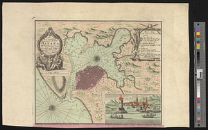
Plan of the city & harbour of Havanna, capital of Cuba

This map is also available in American Revolutionary Geographies Online (ARGO), a collections portal especially built for material relating to the American Revolutionary War Era. Visit ARGO to learn more about this item and explore the historical geography of North America in the late eighteenth century.
Item Information
- Title:
- Plan of the city & harbour of Havanna, capital of Cuba
- Title (alt.):
-
Various plans and draughts of cities, towns, harbours &c. drawn from the latest authorities
- Contributor:
- Conder, Thomas, 1746 or 1747-1831
- Contributor:
- Millar, George Henry
- Date:
-
[1790]
- Format:
-
Maps/Atlases
- Location:
- William L. Clements Library
- Collection (local):
-
William L. Clements Library Collection
- Subjects:
-
Havana (Cuba)--Maps
- Places:
-
CubaHavana (province)Havana
- Extent:
- 1 map : col. ; 12.8 x 10 cm.
- Terms of Use:
-
The University of Michigan Library provides access to these materials for educational and research purposes. These materials may be under copyright. If you decide to use any of these materials, you are responsible for making your own legal assessment and securing any necessary permission. If you have questions about the collection, please contact the William L. Clements Library.
Contact host institution for more information.
- Publisher:
-
[London] :
[George H. Millar]
- Scale:
-
Scale 1:45,000.
- Language:
-
English
- Catalog Record:
-
Catalog record
- Notes:
-
From: Millar's new, complete & universal system of geography. London. [1790].
One of five city plans on the same sheet.
Engraved by: T. Conder.
- Notes (date):
-
This date is inferred.
- Identifier:
-
5677
- Barcode:
-
B2998651