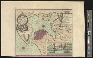
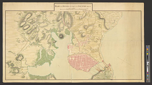
Plan of the Havana with part of the country adjacent
This map is also available in American Revolutionary Geographies Online (ARGO), a collections portal especially built for material relating to the American Revolutionary War Era. Visit ARGO to learn more about this item and explore the historical geography of North America in the late eighteenth century.
Item Information
- Title:
- Plan of the Havana with part of the country adjacent
- Creator:
- Mercier, Henry
- Name on Item:
-
Henry Mercier delin.
- Date:
-
[ca. 1767]
- Format:
-
Maps/Atlases
- Genre:
-
Manuscript maps
- Location:
- William L. Clements Library
- Collection (local):
-
William L. Clements Library Collection
- Subjects:
-
Seven Years' War, 1756-1763--Maps
Havana (Cuba)--Maps
Havana (Cuba)--History--Siege, 1762--Maps
- Places:
-
CubaHavana (province)Havana
- Extent:
- 1 ms. map : col. ; 48.8 x 9 cm
- Terms of Use:
-
The University of Michigan Library provides access to these materials for educational and research purposes. These materials may be under copyright. If you decide to use any of these materials, you are responsible for making your own legal assessment and securing any necessary permission. If you have questions about the collection, please contact the William L. Clements Library.
Contact host institution for more information.
- Scale:
-
Scale 1:10,200.
- Language:
-
English
- Catalog Record:
-
Catalog record
- Notes:
-
Finished, colored topographical map of the city and its harbor as it was in 1762 and showing British siege batteries and their lines of fire.
Note on catalog card attributes map to "Jamaica, 17 Sept., 1767" with no further explanation. This does not appear on map.
- Identifier:
-
605
- Barcode:
-
B1938776