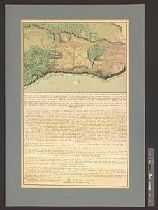
Plan of the battle and situation of the British and French armys on the Heights of Abraham the 28th: of April 1760 : repetition plan no. 2
This map is also available in American Revolutionary Geographies Online (ARGO), a collections portal especially built for material relating to the American Revolutionary War Era. Visit ARGO to learn more about this item and explore the historical geography of North America in the late eighteenth century.
Item Information
- Title:
- Plan of the battle and situation of the British and French armys on the Heights of Abraham the 28th: of April 1760 : repetition plan no. 2
- Date:
-
[ca. 1761]
- Format:
-
Maps/Atlases
- Genre:
-
Manuscript maps
- Location:
- William L. Clements Library
- Collection (local):
-
William L. Clements Library Collection
- Subjects:
-
Sainte-Foy, Battle of, Québec, Québec, 1760--Maps
Québec (Québec)--Maps
United States--History--French and Indian War, 1754-1763--Maps
- Places:
-
CanadaQuebec (province)Québec
- Extent:
- 1 ms. map : col. ; 50.7 x 73.2 cm.
- Terms of Use:
-
The University of Michigan Library provides access to these materials for educational and research purposes. These materials may be under copyright. If you decide to use any of these materials, you are responsible for making your own legal assessment and securing any necessary permission. If you have questions about the collection, please contact the William L. Clements Library.
Contact host institution for more information.
- Scale:
-
Scale 1:9,600.
- Language:
-
English
- Catalog Record:
-
Catalog record
- Notes:
-
Finished, colored, topographical map showing Québec and its immediate vicinity and the movements of military forces during the battle of April 28, 1760.
Table of references identifies major buildings and features of the city and features relating to the 1760 battle.
Additional features are keyed to a full-page table of references on sheet 51 of the atlas.
Map corresponds with an inset map on key map sheet 49.
Map is sheet 53 of the Murray Atlas of Canada and sheet 2 of its series.
- Identifier:
-
705
- Barcode:
-
B3523886