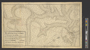
Plan of the camp and battle of Alamance the 16 May 1771 between the provincials of Nth: Carolina, commanded by his excellency Governor Tryon, and rebels who styled themselves Regulators : survey'd and drawn
This map is also available in American Revolutionary Geographies Online (ARGO), a collections portal especially built for material relating to the American Revolutionary War Era. Visit ARGO to learn more about this item and explore the historical geography of North America in the late eighteenth century.
Item Information
- Title:
- Plan of the camp and battle of Alamance the 16 May 1771 between the provincials of Nth: Carolina, commanded by his excellency Governor Tryon, and rebels who styled themselves Regulators : survey'd and drawn
- Creator:
- Sauthier, Claude Joseph
- Name on Item:
-
by C.J. Sauthier
- Date:
-
1771
- Format:
-
Maps/Atlases
- Genre:
-
Manuscript maps
- Location:
- William L. Clements Library
- Collection (local):
-
William L. Clements Library Collection
- Subjects:
-
Alamance Creek, Battle of, N.C., 1771--Maps
- Places:
-
North CarolinaBig Alamance Creek
- Extent:
- 1 ms. map : col. ; 33.6 x 58.3 cm.
- Terms of Use:
-
The University of Michigan Library provides access to these materials for educational and research purposes. These materials may be under copyright. If you decide to use any of these materials, you are responsible for making your own legal assessment and securing any necessary permission. If you have questions about the collection, please contact the William L. Clements Library.
Contact host institution for more information.
- Scale:
-
Scale ca. 1:126,720.
- Language:
-
English
- Catalog Record:
-
Catalog record
- Notes:
-
Finished topographical map of the Salisbury-Hillsborough road where it intersects the Great Alamance River.
A table of references identifies military units and keys them to positions shown on the map.
Clinton Maps 295.
- Identifier:
-
8322
- Barcode:
-
B2503459


