Toggle navigation
LMEC Home
Exhibitions
Georeferencing
Tools for Teachers
Collections
My Favorites
Sign Up / Log In
Search
Search the map portal
Map Collection
Map Collection
Map Sets
Search
Search
Search for
Search In
All Fields
Creator
Title
Subject
Place
Search All Digital Collections
Advanced Search
1253 Results
My Search
Start Over
More Like
commonwealth-oai:pv63kz90b
Remove constraint More Like: commonwealth-oai:pv63kz90b
Filter your Search
Place
North and Central America
1,216
United States
956
Canada
227
New York
193
Quebec
111
Pennsylvania
61
New Jersey
57
Massachusetts
50
more
Place
»
Topic
United States--History--Revolution, 1775-1783--Maps
330
United States--Maps
330
United States--History--French and Indian War, 1754-1763--Maps
151
Saint Lawrence River--Maps
44
Elections--United States--Maps
36
Railroads--United States--Maps
34
Canada--Maps
29
Newport (R.I.)--Maps
27
more
Topic
»
Date
Date range begin
–
Date range end
Current results range from
1700
to
2023
View distribution
Creator
Paullin, Charles Oscar, 1868 or 1869-1944
70
Wright, John Kirtland, 1891-1969
70
Rocque, Mary Ann
29
Bellin, Jacques Nicolas, 1703-1772
26
Holland, Samuel, 1728-1801
25
Jefferys, Thomas, -1771
25
Montrésor, John, 1736-1799
25
Clinton, Henry, Sir, 1738?-1795
19
more
Creator
»
Format
Maps/Atlases
1,235
Drawings/Illustrations
11
Documents
5
Manuscripts
5
Prints
3
Books
1
Objects/Artifacts
1
Posters
1
Georeferenced
Yes
67
No
1,186
Collection
American Revolutionary War-Era Maps
959
William L. Clements Library Collection
909
Norman B. Leventhal Map & Education Center Collection
296
American Antiquarian Society Collection
27
MacLean Collection Map Library
11
Boston and New England Maps
5
Newberry Library Collection
3
Urban Maps
3
more
Collection
»
Available to use
No known restrictions
223
Creative Commons license
9
Search Constraints
Sort by relevance
relevance
title
date (asc)
date (desc)
Number of results to display per page
20 per page
10
per page
20
per page
50
per page
100
per page
View results as:
grid view
map view
Search Results
1021.
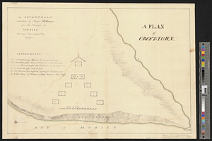
A plan of Croft-town : an encampment intended by Major McKenzie for the troops at Mobile during the unhealthy season
1022.
Plan of Damons land
1023.
Plan of Dean Danl Greens farm in Reading
1024.
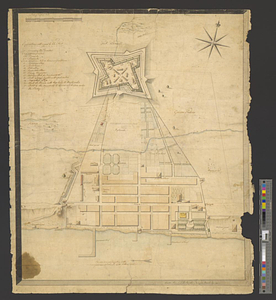
Plan of Detroit with its environs
1025.
Plan of Elizbth Town
1026.
Plan of fifty different tracts of land, (of 1000 acres each) containing in the whole 50,000 acres, situate on the waters of...
1027.
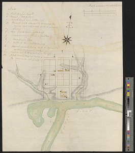
Plan of Fort [Brewerton] at the west end of Onnide Lake
1028.
Plan of Fort Defiance, erected at the confluence of the Miami & Au Glaise rivers in August, 1794
1029.
Plan of Fort Edward situated lat. 43 lon. 72 30'
1030.
Plan of Fort [Franklin] on French Creek : built by a detachment of the 1st U.S. Regt., 1787
1031.
Plan of Fort Frederick at Albany
1032.
A plan of Fort Frederick, situated at the entrance of St. John's River : lat 47 long. 66 30'
1033.
Plan of Fort Frontenac
1034.
Plan of Fort le Quesne, built by the French at the fort of the Ohio and monongahela in 1754
1035.
Plan of Fort Lernoult and the town of Detroit
1036.
A plan of Fort Ligonier done by Theodosius McDonald for George Morton : February 8th annoque domini 1760
1037.
Plan of Fort Massachusetts - Rocklanding - 1792
1038.
Plan of Fort Massachusetts in Georgia and the country adjacent - 1792
1039.
Plan of Fort Niagara, with its environ
1040.
A plan of Fort Ontario
‹ Prev
Next ›
1
2
…
48
49
50
51
52
53
54
55
56
…
62
63


![Plan of Fort [Brewerton] at the west end of Onnide Lake](https://bpldcassets.blob.core.windows.net/derivatives/metadata/commonwealth-oai:639615613/image_thumbnail_300.jpg)

![Plan of Fort [Franklin] on French Creek](https://bpldcassets.blob.core.windows.net/derivatives/metadata/commonwealth-oai:5x21zf368/image_thumbnail_300.jpg)