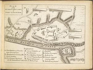
A plan of Fort Ligonier done by Theodosius McDonald for George Morton : February 8th annoque domini 1760

This map is also available in American Revolutionary Geographies Online (ARGO), a collections portal especially built for material relating to the American Revolutionary War Era. Visit ARGO to learn more about this item and explore the historical geography of North America in the late eighteenth century.
Item Information
- Title:
- A plan of Fort Ligonier done by Theodosius McDonald for George Morton : February 8th annoque domini 1760
- Creator:
- McDonald, Theodosius
- Date:
-
February 8, 1760
- Format:
-
Maps/Atlases
- Genre:
-
Manuscript maps
- Location:
- William L. Clements Library
- Collection (local):
-
William L. Clements Library Collection
- Subjects:
-
Christ's Church--Pictorial works
Fort Ligonier (Pa.)--Maps
United States--History--French and Indian War, 1754-1763--Maps
Morton, George
- Places:
-
PennsylvaniaWestmoreland (county)Ligonier
Fort Ligonier
- Extent:
- 1 ms. map : gray wash ; 20 x 32 cm
- Terms of Use:
-
The University of Michigan Library provides access to these materials for educational and research purposes. These materials may be under copyright. If you decide to use any of these materials, you are responsible for making your own legal assessment and securing any necessary permission. If you have questions about the collection, please contact the William L. Clements Library.
Contact host institution for more information.
- Scale:
-
Scale indeterminable.
- Language:
-
English
- Catalog Record:
-
Catalog record
- Notes:
-
Numbered table of references identifies features of fort, and location of battle of October 12, 1758 is identified.
Pasted on verso is engraving entitled: A south east view of Christ's Church.
- Identifier:
-
216
- Barcode:
-
B1936628