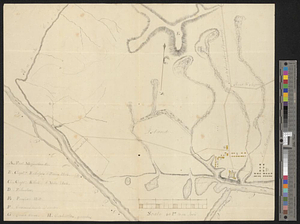
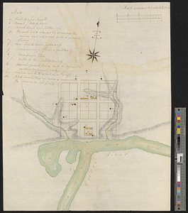
Plan of Fort Massachusetts - Rocklanding - 1792
This map is also available in American Revolutionary Geographies Online (ARGO), a collections portal especially built for material relating to the American Revolutionary War Era. Visit ARGO to learn more about this item and explore the historical geography of North America in the late eighteenth century.
Item Information
- Title:
- Plan of Fort Massachusetts - Rocklanding - 1792
- Date:
-
[1792]
- Format:
-
Maps/Atlases
- Genre:
-
Manuscript maps
- Location:
- William L. Clements Library
- Collection (local):
-
William L. Clements Library Collection
- Subjects:
-
Fort Massachusetts (Ga.)--Maps
Fort Wilkinson (Ga.)--Maps
- Places:
-
GeorgiaBaldwin (county)Milledgeville
- Extent:
- 1 ms. map : col. ; 48 x 38.8 cm.
- Terms of Use:
-
The University of Michigan Library provides access to these materials for educational and research purposes. These materials may be under copyright. If you decide to use any of these materials, you are responsible for making your own legal assessment and securing any necessary permission. If you have questions about the collection, please contact the William L. Clements Library.
Contact host institution for more information.
- Scale:
-
Scale ca. 1:3,168.
- Language:
-
English
- Catalog Record:
-
Catalog record
- Notes:
-
Title from verso.
Finished, colored, topographical map showing fortification and associated buildings outside the walls.
Table of references identifies functions of buildings.
Post, located near Milledgeville, later known as Fort Wilkinson.
- Notes (date):
-
This date is inferred.
- Identifier:
-
8706
- Barcode:
-
B2644426