Toggle navigation
LMEC Home
Exhibitions
Georeferencing
Tools for Teachers
Collections
My Favorites
Sign Up / Log In
Search
Search the map portal
Map Collection
Map Collection
Map Sets
Search
Search
Search for
Search In
All Fields
Creator
Title
Subject
Place
Search All Digital Collections
Advanced Search
971 Results
My Search
Start Over
More Like
commonwealth-oai:j9606006g
Remove constraint More Like: commonwealth-oai:j9606006g
Filter your Search
Place
North and Central America
943
United States
682
New York
228
Canada
205
Quebec
111
Pennsylvania
61
New Jersey
60
Massachusetts
48
more
Place
»
Topic
United States--History--Revolution, 1775-1783--Maps
328
United States--History--French and Indian War, 1754-1763--Maps
149
Manhattan (New York, N.Y.)--Maps
47
Saint Lawrence River--Maps
43
Newport (R.I.)--Maps
27
New York (N.Y.)--Maps
26
New York (State)--Maps
25
Hudson River (N.Y. and N.J.)--Maps
21
more
Topic
»
Date
Date range begin
–
Date range end
Current results range from
1700
to
1939
View distribution
Creator
Rocque, Mary Ann
29
Holland, Samuel, 1728-1801
25
Montrésor, John, 1736-1799
25
Bellin, Jacques Nicolas, 1703-1772
24
Jefferys, Thomas, -1771
24
Clinton, Henry, Sir, 1738?-1795
18
Robert Sayer and John Bennett (Firm)
16
Hills, John, active 1777-1819
13
more
Creator
»
Format
Maps/Atlases
955
Drawings/Illustrations
11
Documents
5
Manuscripts
4
Prints
1
Georeferenced
Yes
10
No
961
Collection
American Revolutionary War-Era Maps
929
William L. Clements Library Collection
909
Norman B. Leventhal Map & Education Center Collection
43
Urban Maps
22
American Antiquarian Society Collection
7
Boston and New England Maps
6
New York Public Library Collection
3
New-York Historical Society Collection
3
more
Collection
»
Available to use
No known restrictions
46
Creative Commons license
6
Search Constraints
Sort by relevance
relevance
title
date (asc)
date (desc)
Number of results to display per page
20 per page
10
per page
20
per page
50
per page
100
per page
View results as:
grid view
map view
Search Results
1.
British troop dispositions in and near New York City, July and August 1781
2.
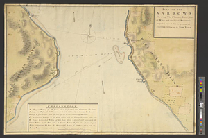
Plan of the narrows : shewing, the channel, shoal, depth of water, and the several battery's proposed on each side to prevent...
3.
Situation des posten zu Denyses Ferry auf Long Island wie solcher den 7ten October 1781 von furste : Braunshweig und Hessen...
4.
Sketch of the country illustrating the late engagement in Long Island
5.
Disposition of the British forces on Long Island, Staten Island, and Manhattan Island, under Cornwallis and Knyphausen
6.
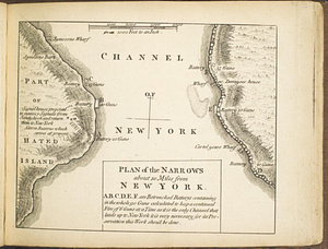
Plan of the narrows about 10 miles from New York
7.
A plan of New York Island with the circumjacent country as far as Dobb's Ferry to the north, and White-Plains the the east;...
8.
The seat of action between the British and American forces or an authentic plan of Staten Island with the neighbouring...
9.
The seat of action, between the British and American forces or an authentic plan of the western part of Long Island, with the...
10.
A sketch of the disposition of the force at New York for the defence of the port
11.
British troop dispositions in and near New York City
12.
Long Island
13.
Sketch of the position of the army on Long Island upon the morning of the 26th of August, 1776; with the march on the ensuing...
14.
Isle de Newyork : reconnaissance des ouvrages du nord de lisle de Newyork faite en presence des Généraux, Wasington et...
15.
Kings Bridge
16.
Map of New York I. with the adjacent rocks and other remarkable parts of Hell-Gate
17.
A map of the country adjacent to Kingsbridge, surveyed by order of his excellency General Sir Henry Clinton K.B., commander in...
18.
Part of the modern counties of Westchester and Bronx
19.
Plan des environs de Kingsbridge jusqu'au Fort Knyphausen avec les ouvrages de fortification faites dans l'année 1779 & de ceux...
20.
Plan des ouvrages faites en front du fort Knyphausen, New Yorck ce 4 me. Novr 1779
‹ Prev
Next ›
1
2
3
4
5
…
48
49