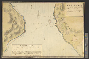
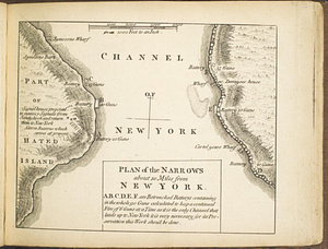
Plan of the narrows about 10 miles from New York
This map is also available in American Revolutionary Geographies Online (ARGO), a collections portal especially built for material relating to the American Revolutionary War Era. Visit ARGO to learn more about this item and explore the historical geography of North America in the late eighteenth century.
Item Information
- Title:
- Plan of the narrows about 10 miles from New York
- Contributor:
- Rocque, Mary Ann
- Date:
-
[1763]
- Format:
-
Maps/Atlases
- Location:
- William L. Clements Library
- Collection (local):
-
William L. Clements Library Collection
- Subjects:
-
New York Harbor (N.Y. and N.J.)--Maps
Staten Island (New York, N.Y.)--Maps
Long Island (N.Y.)--Maps
United States--History--French and Indian War, 1754-1763--Maps
- Places:
-
New YorkRichmond (county)Staten Island (island)
New YorkLong Island (island)
- Extent:
- 1 map ; 12.2 x 16 cm
- Terms of Use:
-
The University of Michigan Library provides access to these materials for educational and research purposes. These materials may be under copyright. If you decide to use any of these materials, you are responsible for making your own legal assessment and securing any necessary permission. If you have questions about the collection, please contact the William L. Clements Library.
Contact host institution for more information.
- Publisher:
-
[London] :
[M.A. Rocque]
- Scale:
-
Scale 1:24,000.
- Language:
-
English
- Catalog Record:
-
Catalog record
- Notes:
-
In: Rocque, Mary Ann. A set of plans and forts ..., 1763, no. 22.
Shows Verrazano Narrows and batteries established on each side.
- Notes (date):
-
This date is inferred.
- Identifier:
-
961
- Barcode:
-
B1937225