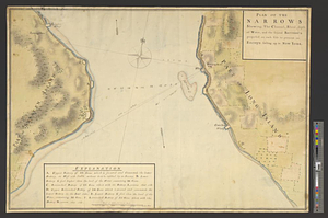
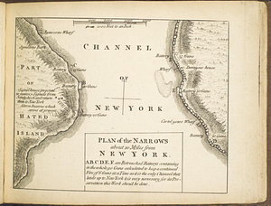
Situation des posten zu Denyses Ferry auf Long Island wie solcher den 7ten October 1781 von furste : Braunshweig und Hessen Hanauischen trouppen unter dem commando des Capitain von Wolzogen ist besetzt worden

This map is also available in American Revolutionary Geographies Online (ARGO), a collections portal especially built for material relating to the American Revolutionary War Era. Visit ARGO to learn more about this item and explore the historical geography of North America in the late eighteenth century.
Item Information
- Title:
- Situation des posten zu Denyses Ferry auf Long Island wie solcher den 7ten October 1781 von furste : Braunshweig und Hessen Hanauischen trouppen unter dem commando des Capitain von Wolzogen ist besetzt worden
- Creator:
- Wissell, Heinrich Ferdinand von
- Date:
-
1781
- Format:
-
Maps/Atlases
- Genre:
-
Manuscript maps
- Location:
- William L. Clements Library
- Collection (local):
-
William L. Clements Library Collection
- Subjects:
-
New York Harbor (N.Y. and N.J.)--Maps
Staten Island (New York, N.Y.)--Maps
Long Island (N.Y.)--Maps
United States--History--Revolution, 1775-1783--Maps
Wolzogen, Capitain von
- Places:
-
New YorkRichmond (county)Staten Island (island)
New YorkLong Island (island)
- Extent:
- 1 ms. map : col. ; 30.7 x 43.5 cm.
- Terms of Use:
-
The University of Michigan Library provides access to these materials for educational and research purposes. These materials may be under copyright. If you decide to use any of these materials, you are responsible for making your own legal assessment and securing any necessary permission. If you have questions about the collection, please contact the William L. Clements Library.
Contact host institution for more information.
- Scale:
-
Scale of paces.
- Language:
-
German
- Catalog Record:
-
Catalog record
- Notes:
-
Signed below neat line at lower right: Heinr. Ferd. v. Wissell fec.
Finished, colored, topographical map of the narrows between Long Island and Staten Island showing the ferry and defensive works on both shores.
A number of property owners are identified on the Long Island shore.
Table of references identifies the huts occupied by the Brunswick and Hesse Hanau troops.
Clinton Map 201.
- Identifier:
-
8658
- Barcode:
-
B2839098