Toggle navigation
LMEC Home
Exhibitions
Georeferencing
Tools for Teachers
Collections
My Favorites
Sign Up / Log In
Search
Search the map portal
Map Collection
Map Collection
Map Sets
Search
Search
Search for
Search In
All Fields
Creator
Title
Subject
Place
Search All Digital Collections
Advanced Search
941 Results
My Search
Start Over
More Like
commonwealth-oai:hx122d65d
Remove constraint More Like: commonwealth-oai:hx122d65d
Filter your Search
Place
North and Central America
915
United States
654
Canada
205
New York
199
Quebec
111
Pennsylvania
90
New Jersey
62
Nova Scotia
48
more
Place
»
Topic
United States--History--Revolution, 1775-1783--Maps
305
United States--History--French and Indian War, 1754-1763--Maps
149
Pennsylvania--Maps
50
Saint Lawrence River--Maps
43
New York (State)--Maps
32
Newport (R.I.)--Maps
27
New Jersey--Maps
22
Hudson River (N.Y. and N.J.)--Maps
21
more
Topic
»
Date
Date range begin
–
Date range end
Current results range from
1700
to
1921
View distribution
Creator
Rocque, Mary Ann
29
Bellin, Jacques Nicolas, 1703-1772
25
Holland, Samuel, 1728-1801
25
Montrésor, John, 1736-1799
25
Jefferys, Thomas, -1771
24
Clinton, Henry, Sir, 1738?-1795
19
Robert Sayer and John Bennett (Firm)
15
Hills, John, active 1777-1819
13
more
Creator
»
Format
Maps/Atlases
925
Drawings/Illustrations
11
Documents
5
Manuscripts
1
Prints
1
Georeferenced
Yes
7
No
934
Collection
American Revolutionary War-Era Maps
916
William L. Clements Library Collection
909
Norman B. Leventhal Map & Education Center Collection
27
Maps from AAS
4
MacLean Collection Map Library
1
Urban Maps
1
Available to use
No known restrictions
27
Search Constraints
Sort by relevance
relevance
title
date (asc)
date (desc)
Number of results to display per page
20 per page
10
per page
20
per page
50
per page
100
per page
View results as:
grid view
map view
Search Results
241.
Ein grund-ris von der Festung Duquesne ...
242.
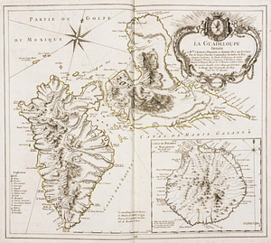
La Guadeloupe : dediée à Mgr. Charles Phillippe d'Albert, duc de Luynes ...
243.
The Gulf coast from the Mississippi Delta to the Bay of St. Joseph
244.
Halifax
245.
The harbour of Halifax
246.
Hare Island; Pointe aux Allouettes of Larks Point; English Bank
247.
Haverstraw Bay and vicinity
248.
Hudson River from Anthony's Nose to Stony Point
249.
Hudson River from Peekskill to Slaughters Landing
250.
Hudson River from Stony Point to West Point
251.
Hudson River from West Point to Dobbs Ferry
252.
Hudson River highlands at Martelaers Rock
253.
Hudson's River from New York to Albany
254.
Hudson's River from Stony Pt. to Fort Montgomery
255.
Hydro-geographical map representing part of Sandwich Gulf, and of the New Bahama Channel, the northernmost extent of the Martir...
256.
Illinois River
257.
Isabella Bay on North side of Hispaniola
258.
Island of Dominica
259.
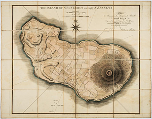
The island of St Eustatius corruptly St Eustatia : to Monsieur le Marquie de Bouillé this plan engraved from the original in...
260.
Isle de Newyork : reconnaissance des ouvrages du nord de lisle de Newyork faite en presence des Généraux, Wasington et...
‹ Prev
Next ›
1
2
…
9
10
11
12
13
14
15
16
17
…
47
48