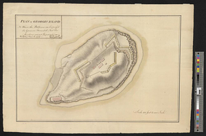
The harbour of Halifax

This map is also available in American Revolutionary Geographies Online (ARGO), a collections portal especially built for material relating to the American Revolutionary War Era. Visit ARGO to learn more about this item and explore the historical geography of North America in the late eighteenth century.
Item Information
- Title:
- The harbour of Halifax
- Date:
-
[1767]
- Format:
-
Maps/Atlases
- Genre:
-
Manuscript maps
- Location:
- William L. Clements Library
- Collection (local):
-
William L. Clements Library Collection
- Subjects:
-
Halifax (N.S.)--Maps
- Places:
-
CanadaNova Scotia (province)Halifax
- Extent:
- 1 ms. map : col. ; 83.8 x 62 cm
- Terms of Use:
-
The University of Michigan Library provides access to these materials for educational and research purposes. These materials may be under copyright. If you decide to use any of these materials, you are responsible for making your own legal assessment and securing any necessary permission. If you have questions about the collection, please contact the William L. Clements Library.
Contact host institution for more information.
- Scale:
-
Scale 1:4,800.
- Language:
-
English
- Catalog Record:
-
Catalog record
- Notes:
-
Finished, colored, topographical map of the town of Halifax and immediately adjacent country showing town blocks as well as many individual buildings on the outskirts.
Names are shown for most of the wharves, and streets are projected beyond the built-up part of town.
Much detail shown of naval dockyard.
Clinton Maps 1.
- Notes (date):
-
This date is inferred.
- Identifier:
-
8260
- Barcode:
-
B1938104