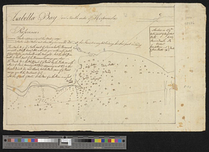
Isabella Bay on North side of Hispaniola
This map is also available in American Revolutionary Geographies Online (ARGO), a collections portal especially built for material relating to the American Revolutionary War Era. Visit ARGO to learn more about this item and explore the historical geography of North America in the late eighteenth century.
Item Information
- Title:
- Isabella Bay on North side of Hispaniola
- Creator:
- Mc. P. Rice, William, cartographer
- Date:
-
[1787]
- Format:
-
Maps/Atlases
- Genre:
-
Manuscript maps
- Location:
- William L. Clements Library
- Collection (local):
-
William L. Clements Library Collection
- Subjects:
-
La Isabela (Dominican Republic)--Maps
- Places:
-
Dominican RepublicPuerto Plata (province)
La Isabela
- Extent:
- 1 manuscript map ; 22.5 x 32 cm
- Terms of Use:
-
The University of Michigan Library provides access to these materials for educational and research purposes. These materials may be under copyright. If you decide to use any of these materials, you are responsible for making your own legal assessment and securing any necessary permission. If you have questions about the collection, please contact the William L. Clements Library.
Contact host institution for more information.
- Scale:
-
Scale indeterminable.
- Language:
-
English
- Catalog Record:
-
Catalog record
- Notes:
-
North oriented to left.
Relief shown pictorially; depths shown by soundings.
Pen and ink plan of Isabella Bay (La Isabela, Dominican Republic) with notes on sailing approaches and anchorages.
Authorship and date from similar map of Lucca Harbor, Jamaica, per dealer notes.
Includes coastal profile at upper right and references to geographical features.
- Notes (date):
-
This date is inferred.
- Identifier:
-
5659
- Barcode:
-
B9006254


