Toggle navigation
LMEC Home
Exhibitions
Georeferencing
Tools for Teachers
Collections
My Favorites
Sign Up / Log In
Search
Search the map portal
Map Collection
Map Collection
Map Sets
Search
Search
Search for
Search In
All Fields
Creator
Title
Subject
Place
Search All Digital Collections
Advanced Search
1012 Results
My Search
Start Over
More Like
commonwealth-oai:gx41rh29r
Remove constraint More Like: commonwealth-oai:gx41rh29r
Filter your Search
Place
North and Central America
984
United States
715
Canada
206
New York
201
Quebec
112
Pennsylvania
90
New Jersey
79
Virginia
51
more
Place
»
Topic
United States--History--Revolution, 1775-1783--Maps
330
United States--History--French and Indian War, 1754-1763--Maps
149
Pennsylvania--Maps
50
Saint Lawrence River--Maps
43
New Jersey--Maps
40
Maryland--Maps
37
New York (State)--Maps
34
Newport (R.I.)--Maps
27
more
Topic
»
Date
Date range begin
–
Date range end
Current results range from
1700
to
1931
View distribution
Creator
Rocque, Mary Ann
29
Bellin, Jacques Nicolas, 1703-1772
26
Holland, Samuel, 1728-1801
26
Jefferys, Thomas, -1771
25
Montrésor, John, 1736-1799
25
Clinton, Henry, Sir, 1738?-1795
19
Robert Sayer and John Bennett (Firm)
16
Hills, John, active 1777-1819
13
more
Creator
»
Format
Maps/Atlases
996
Drawings/Illustrations
11
Documents
5
Manuscripts
5
Prints
1
Georeferenced
Yes
32
No
980
Collection
American Revolutionary War-Era Maps
947
William L. Clements Library Collection
909
Norman B. Leventhal Map & Education Center Collection
71
American Antiquarian Society Collection
16
MacLean Collection Map Library
6
Boston and New England Maps
5
Urban Maps
5
Newberry Library Collection
3
more
Collection
»
Available to use
No known restrictions
73
Creative Commons license
5
Search Constraints
Sort by relevance
relevance
title
date (asc)
date (desc)
Number of results to display per page
20 per page
10
per page
20
per page
50
per page
100
per page
View results as:
grid view
map view
Search Results
361.
A plan of the northern part of New Jersey : shewing the positions of the American and British armies after crossing the North...
362.
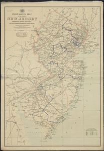
Post route map of the State of New Jersey showing post offices with the intermediate distances on mail routes in operation on...
363.
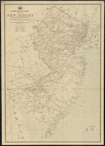
Post route map of the state of New Jersey showing post offices with the intermediate distances on mail routes in operation on...
364.
The provinces of New York, and New Jersey, : with part of Pensilvania [sic], and the province of Quebec
365.
Rand, McNally & Co.'s New Jersey
366.
Relief map of New Jersey
367.
Seat of war in Virginia and Maryland
368.
Smith's topographical map of Virginia and Maryland
369.
The state of Maryland, from the best authorities
370.
The State of New Jersey
371.
The State of New Jersey : from original surveys based on the triangulation of the U.S. Coast and Geodetic Survey
372.
The state of New Jersey : economic geology
373.
The state of New Jersey, compiled from the most authentic information
374.
State of West Virginia and part of Maryland : coal fields and producing districts
375.
Carte de la Nouvelle Angleterre, Nouvelle Yorck, et Pensilvanie. : Pour servir à l'Histoire générale des voyages
376.
Clemens' map of Pennsylvania
377.
Geological and topographical map of the anthracite fields of Pennsylvania : constructed from original explorations and surveys
378.
Geological map of south-west Pennsylvania, with special reference to the Pittsburgh coal bed
379.
Grundriss von Philadelphia der hauptstadt in Pensylvanien und umliegenden Gegend
380.
A map of Pensylvania, with part of the adjacent states, from the latest surveys
‹ Prev
Next ›
1
2
…
15
16
17
18
19
20
21
22
23
…
50
51