Toggle navigation
LMEC Home
Exhibitions
Georeferencing
Tools for Teachers
Collections
My Favorites
Sign Up / Log In
Search
Search the map portal
Map Collection
Map Collection
Map Sets
Search
Search
Search for
Search In
All Fields
Creator
Title
Subject
Place
Search All Digital Collections
Advanced Search
1254 Results
My Search
Start Over
More Like
commonwealth-oai:g158gg63r
Remove constraint More Like: commonwealth-oai:g158gg63r
Filter your Search
Place
North and Central America
1,224
United States
942
Canada
251
New York
196
Quebec
112
Pennsylvania
61
New Jersey
54
Nova Scotia
49
more
Place
»
Topic
United States--Maps
330
United States--History--Revolution, 1775-1783--Maps
305
United States--History--French and Indian War, 1754-1763--Maps
152
Canada--Maps
55
Saint Lawrence River--Maps
44
Elections--United States--Maps
36
Railroads--United States--Maps
34
New York (State)--Maps
27
more
Topic
»
Date
Date range begin
–
Date range end
Current results range from
1700
to
2023
View distribution
Creator
Paullin, Charles Oscar, 1868 or 1869-1944
70
Wright, John Kirtland, 1891-1969
70
Rocque, Mary Ann
29
Bellin, Jacques Nicolas, 1703-1772
26
Holland, Samuel, 1728-1801
25
Montrésor, John, 1736-1799
25
Jefferys, Thomas, -1771
24
Clinton, Henry, Sir, 1738?-1795
19
more
Creator
»
Format
Maps/Atlases
1,236
Drawings/Illustrations
11
Documents
5
Prints
3
Books
1
Manuscripts
1
Objects/Artifacts
1
Posters
1
Georeferenced
Yes
67
No
1,187
Collection
American Revolutionary War-Era Maps
942
William L. Clements Library Collection
909
Norman B. Leventhal Map & Education Center Collection
312
Maps from AAS
23
MacLean Collection Map Library
9
Boston and New England Maps
2
David Judkins Weaver Papers
2
Mapping Boston Collection
2
more
Collection
»
Available to use
No known restrictions
237
Creative Commons license
5
Search Constraints
Sort by relevance
relevance
title
date (asc)
date (desc)
Number of results to display per page
20 per page
10
per page
20
per page
50
per page
100
per page
View results as:
grid view
map view
Search Results
1041.
Plan of the town of Boston
1042.
Plan of the town of Boston with the attack on Bunkers-Hill in the peninsula of Charlestown the 17th of June 1775
1043.
A plan of the town of Dracut protracted by a scale of 200 rods to an inch : taken in Octobr. 1791
1044.
A plan of the town of Halifax in Nova Scotia
1045.
A plan of the town of Halifax in Nova Scotia August 1749
1046.
A plan of the town of Medford in the county of Middlesex and commonwealth of Massachusetts containing 5631 acres including...
1047.
Plan of the town of Montreal
1048.
A plan of the town of Newbern in Craven County, North Carolina : survey'd and drawn in 1769
1049.
Plan of the town of Newport, and the adjacent country; with a project for its defence : (no. 7)
1050.
Plan of the town of Newport and the adjacent country, with a project for its defence
1051.
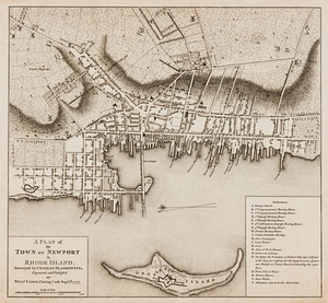
A plan of the town of Newport in Rhode Island
1052.
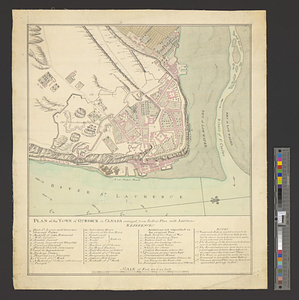
Plan of the town of Quebeck in Canada enlarged from Bellin's plan, with additions
1053.
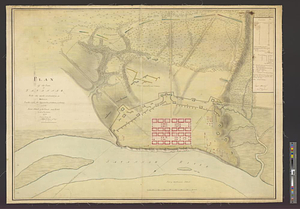
Plan of the town of Savannah, with the works constructed for its defence, together with the approaches & batteries of the...
1054.
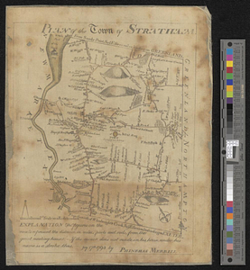
Plan of the town of Stratham... : July 17th, 1793
1055.
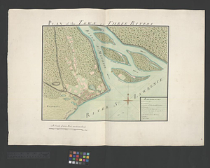
Plan of the town of Three Rivers
1056.
A plan of the town spot of Morris Town in Morris County for about three miles from the court house, made out from a view of the...
1057.
Plan of the works, which form the exterior line of defence, for the town of New-Port in Rhode Island : also of the batteries...
1058.
Plan of three tracts of land, situate on the river Ohio, in district no. 3. state of Pennsylvania : survey'd in July, 1785
1059.
A plan of two routs propose for the Middlesex Canal, in which Mistic River, ponds &c, as far up as Symmes's, are copied from...
1060.
Plan of Washingtons position
‹ Prev
Next ›
1
2
…
49
50
51
52
53
54
55
56
57
…
62
63