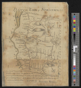
Plan of the town of Stratham... : July 17th, 1793
This map is also available in American Revolutionary Geographies Online (ARGO), a collections portal especially built for material relating to the American Revolutionary War Era. Visit ARGO to learn more about this item and explore the historical geography of North America in the late eighteenth century.
Item Information
- Title:
- Plan of the town of Stratham... : July 17th, 1793
- Creator:
- Merrill, Phinehas, 1767-1815
- Name on Item:
-
by Phinehas Merrill
- Date:
-
[1793]
- Format:
-
Maps/Atlases
- Location:
- William L. Clements Library
- Collection (local):
-
William L. Clements Library Collection
- Subjects:
-
Stratham (N.H. : Town)--Maps
- Places:
-
New HampshireRockingham (county)Stratham
- Extent:
- 1 map : col. ; 24.4 x 19.2 cm.
- Terms of Use:
-
The University of Michigan Library provides access to these materials for educational and research purposes. These materials may be under copyright. If you decide to use any of these materials, you are responsible for making your own legal assessment and securing any necessary permission. If you have questions about the collection, please contact the William L. Clements Library.
Contact host institution for more information.
- Scale:
-
Scale 200 rods to 1 inch.
- Language:
-
English
- Catalog Record:
-
Catalog record
- Notes:
-
Map of town showing many individual farmhouses with names of owners.
- Notes (date):
-
This date is inferred.
- Identifier:
-
5692
- Barcode:
-
B3001197


