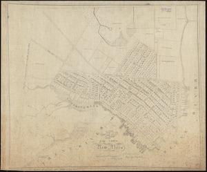
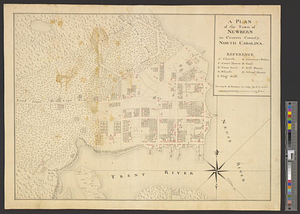
A plan of the town of Newbern in Craven County, North Carolina : survey'd and drawn in 1769
This map is also available in American Revolutionary Geographies Online (ARGO), a collections portal especially built for material relating to the American Revolutionary War Era. Visit ARGO to learn more about this item and explore the historical geography of North America in the late eighteenth century.
Item Information
- Title:
- A plan of the town of Newbern in Craven County, North Carolina : survey'd and drawn in 1769
- Creator:
- Sauthier, Claude Joseph
- Name on Item:
-
by C.J. Sauthier
- Date:
-
1769
- Format:
-
Maps/Atlases
- Genre:
-
Manuscript maps
- Location:
- William L. Clements Library
- Collection (local):
-
William L. Clements Library Collection
- Subjects:
-
New Bern (N.C.)--Maps
- Places:
-
North CarolinaCraven (county)New Bern
- Extent:
- 1 ms. map : col. ; 40.7 x 53.3 cm.
- Terms of Use:
-
The University of Michigan Library provides access to these materials for educational and research purposes. These materials may be under copyright. If you decide to use any of these materials, you are responsible for making your own legal assessment and securing any necessary permission. If you have questions about the collection, please contact the William L. Clements Library.
Contact host institution for more information.
- Scale:
-
Scale 1:4,680.
- Language:
-
English
- Catalog Record:
-
Catalog record
- Notes:
-
Finished topographical map of the town with a table of references identifying important buildings.
Major houses colored in red.
Clinton Maps 294.
- Identifier:
-
8257
- Barcode:
-
B2503448