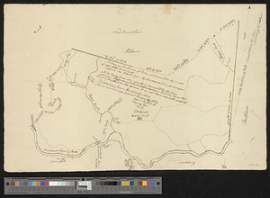
A plan of the town of Dracut protracted by a scale of 200 rods to an inch : taken in Octobr. 1791
This map is also available in American Revolutionary Geographies Online (ARGO), a collections portal especially built for material relating to the American Revolutionary War Era. Visit ARGO to learn more about this item and explore the historical geography of North America in the late eighteenth century.
Item Information
- Title:
- A plan of the town of Dracut protracted by a scale of 200 rods to an inch : taken in Octobr. 1791
- Contributor:
- Baldwin, T. F.
- Contributor:
- Baldwin, Loammi, 1780-1838
- Creator:
- French, Frederick, surveyor
- Name on Item:
-
by Frederick French, surveyor
- Date:
-
February 23, 1807
- Format:
-
Maps/Atlases
- Genre:
-
Manuscript maps
- Location:
- William L. Clements Library
- Collection (local):
-
William L. Clements Library Collection
- Subjects:
-
Dracut (Mass. : Town)--Maps
- Places:
-
MassachusettsMiddlesex (county)Dracut
- Extent:
- 1 ms. map ; 25.4 x 39.7 cm.
- Terms of Use:
-
The University of Michigan Library provides access to these materials for educational and research purposes. These materials may be under copyright. If you decide to use any of these materials, you are responsible for making your own legal assessment and securing any necessary permission. If you have questions about the collection, please contact the William L. Clements Library.
Contact host institution for more information.
- Scale:
-
Scale 200 rods to 1 inch.
- Language:
-
English
- Catalog Record:
-
Catalog record
- Notes:
-
Pen and ink map of Dracut showing some principal features such as the meeting house, the locations of bridges, and some mills.
Copied by T.F. B[aldwin] Febry. 23, 1807.
Initialled L.B. (Loammi Baldwin) below copy notation.
- Identifier:
-
5686
- Barcode:
-
B2999766


