Toggle navigation
LMEC Home
Exhibitions
Georeferencing
Tools for Teachers
Collections
My Favorites
Sign Up / Log In
Search
Search the map portal
Map Collection
Map Collection
Map Sets
Search
Search
Search for
Search In
All Fields
Creator
Title
Subject
Place
Search All Digital Collections
Advanced Search
1021 Results
My Search
Start Over
More Like
commonwealth-oai:9306xx619
Remove constraint More Like: commonwealth-oai:9306xx619
Filter your Search
Place
North and Central America
993
United States
730
New York
254
Canada
208
Quebec
112
New Jersey
81
Pennsylvania
71
Massachusetts
52
more
Place
»
Topic
United States--History--Revolution, 1775-1783--Maps
330
United States--History--French and Indian War, 1754-1763--Maps
150
New York (State)--Maps
85
Saint Lawrence River--Maps
43
New Jersey--Maps
40
Pennsylvania--Maps
29
Newport (R.I.)--Maps
27
Hudson River (N.Y. and N.J.)--Maps
23
more
Topic
»
Date
Date range begin
–
Date range end
Current results range from
1700
to
1976
View distribution
Creator
Rocque, Mary Ann
29
Holland, Samuel, 1728-1801
26
Bellin, Jacques Nicolas, 1703-1772
25
Jefferys, Thomas, -1771
25
Montrésor, John, 1736-1799
25
Clinton, Henry, Sir, 1738?-1795
18
Robert Sayer and John Bennett (Firm)
16
Hills, John, active 1777-1819
13
more
Creator
»
Format
Maps/Atlases
1,005
Manuscripts
12
Drawings/Illustrations
11
Documents
5
Prints
1
Georeferenced
Yes
21
No
1,000
Collection
American Revolutionary War-Era Maps
955
William L. Clements Library Collection
909
Norman B. Leventhal Map & Education Center Collection
70
Boston and New England Maps
18
Maps from AAS
17
New-York Historical Society Collection
9
MacLean Collection Map Library
7
Newberry Library Collection
3
more
Collection
»
Available to use
No known restrictions
79
Creative Commons license
6
Search Constraints
Sort by relevance
relevance
title
date (asc)
date (desc)
Number of results to display per page
20 per page
10
per page
20
per page
50
per page
100
per page
View results as:
grid view
map view
Search Results
301.
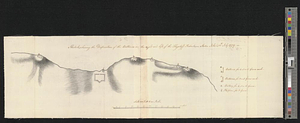
A sketch of the east end of the peninsula where on is Hampton
302.
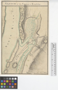
Sketch of the environs of King's bridge
303.
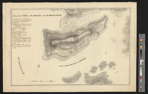
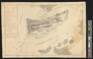
Sketch of the neck and harbour of Majabigwaduce
304.
Sketch of the neck and harbour of Majabigwaduce 20th Aug. 1779
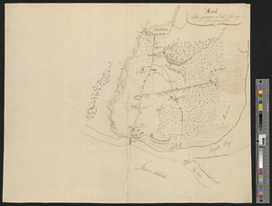
305.
Sketch of the position of the army, 17th of June 1780
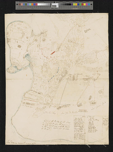
306.
Sketch of the position of the army on Long Island upon the morning of the 26th of August, 1776; with the march on the ensuing...
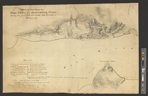
307.
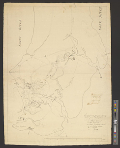
Sketch of the posts of York Town and Gloucester Point shewing the French and rebel attacks upon the former in October, 1781
308.
Sketch of the roads from Kings Bridge to the White Plains and parts ajacent shewing the encampment of his majestys forces under...
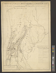
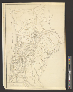
309.
Sketch of the roads from Kings Bridge to the White Plains and parts ajacent shewing the encampment of his majestys forces under...
310.
Sketch, shewing the disposition of the batteries, on the right and left, of the Flagstaff Redout : Staten Island, 12th July 1779
311.
St. Eustatia topographically drawn & humbly dedicated to his excellency John Vaughan commander in chief of his majestys forces...
312.
Stony Point
313.
Sullivans Island
314.
A survey of Lake Champlain, including Lake George, Crown Point and St. John : surveyed by order of his excellency Major-General...
315.
A survey of the defile and that part of York Island adjacent to Fort Knyphausen
316.
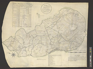
A survey of the peninsula of Charles Town shewing the three posts now garrison'd by his majesty's troops for the winter : 10th...
317.
Thirty-miles round Boston
318.
This sketch represents nearly the figure and proportions of the work in front of the dock yard at Hallifax as it was traced and...
319.
To his e[xcellency] G. Washington commander in chief of the armies of the United States of America this plan of the investment...
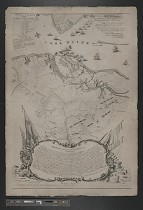
320.
To his excellency General Washington, commander in chief of the armies of the United States of America : this plan of the...
‹ Prev
Next ›
1
2
…
12
13
14
15
16
17
18
19
20
…
51
52


![To his e[xcellency] G. Washington commander in chief of the armies of the United States of America this plan of the investment of York and Goucester [sic] has been surveyed and laid down, and is most humbly dedicated](https://bpldcassets.blob.core.windows.net/derivatives/metadata/commonwealth-oai:9g552g940/image_thumbnail_300.jpg)