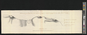
Sketch, shewing the disposition of the batteries, on the right and left, of the Flagstaff Redout : Staten Island, 12th July 1779
This map is also available in American Revolutionary Geographies Online (ARGO), a collections portal especially built for material relating to the American Revolutionary War Era. Visit ARGO to learn more about this item and explore the historical geography of North America in the late eighteenth century.
Item Information
- Title:
- Sketch, shewing the disposition of the batteries, on the right and left, of the Flagstaff Redout : Staten Island, 12th July 1779
- Date:
-
July 12, 1779
- Format:
-
Maps/Atlases
- Genre:
-
Manuscript maps
- Location:
- William L. Clements Library
- Collection (local):
-
William L. Clements Library Collection
- Subjects:
-
Staten Island (New York, N.Y.)--Maps
United States--History--Revolution, 1775-1783--Maps
- Places:
-
New YorkRichmond (county)Staten Island (island)
- Extent:
- 1 ms. map ; 17.6 x 59.4 cm.
- Terms of Use:
-
The University of Michigan Library provides access to these materials for educational and research purposes. These materials may be under copyright. If you decide to use any of these materials, you are responsible for making your own legal assessment and securing any necessary permission. If you have questions about the collection, please contact the William L. Clements Library.
Contact host institution for more information.
- Scale:
-
Scale 1:2,400.
- Language:
-
English
- Catalog Record:
-
Catalog record
- Notes:
-
Finished, pen and ink topographical map showing the fortifications facing the narrows between Staten and Long islands.
Table of references gives the armament of each fortification.
Clinton Map 197.
- Identifier:
-
8407
- Barcode:
-
B2821944