Toggle navigation
LMEC Home
Exhibitions
Georeferencing
Tools for Teachers
Collections
My Favorites
Sign Up / Log In
Search
Search the map portal
Map Collection
Map Collection
Map Sets
Search
Search
Search for
Search In
All Fields
Creator
Title
Subject
Place
Search All Digital Collections
Advanced Search
1014 Results
My Search
Start Over
More Like
commonwealth-oai:3r078t62x
Remove constraint More Like: commonwealth-oai:3r078t62x
Filter your Search
Place
North and Central America
988
United States
726
Canada
206
New York
201
Quebec
112
Pennsylvania
90
New Jersey
79
Virginia
73
more
Place
»
Topic
United States--History--Revolution, 1775-1783--Maps
308
United States--History--French and Indian War, 1754-1763--Maps
149
Pennsylvania--Maps
50
Virginia--Maps
47
Saint Lawrence River--Maps
43
New Jersey--Maps
40
Maryland--Maps
37
New York (State)--Maps
34
more
Topic
»
Date
Date range begin
–
Date range end
Current results range from
1700
to
1988
View distribution
Creator
Rocque, Mary Ann
29
Bellin, Jacques Nicolas, 1703-1772
26
Holland, Samuel, 1728-1801
26
Montrésor, John, 1736-1799
25
Jefferys, Thomas, -1771
24
Clinton, Henry, Sir, 1738?-1795
19
Robert Sayer and John Bennett (Firm)
15
Hills, John, active 1777-1819
13
more
Creator
»
Format
Maps/Atlases
998
Drawings/Illustrations
11
Documents
5
Manuscripts
2
Prints
1
Georeferenced
Yes
39
No
975
Collection
American Revolutionary War-Era Maps
934
William L. Clements Library Collection
909
Norman B. Leventhal Map & Education Center Collection
86
Maps from AAS
13
MacLean Collection Map Library
5
Urban Maps
2
David Judkins Weaver Papers
1
New York Public Library Collection
1
Available to use
No known restrictions
86
Creative Commons license
1
Search Constraints
Sort by relevance
relevance
title
date (asc)
date (desc)
Number of results to display per page
20 per page
10
per page
20
per page
50
per page
100
per page
View results as:
grid view
map view
Search Results
361.
M. Progues wood land
362.
Manicouagan Shoals; Havre St. Nicholas; Bay of the Seven Islands
363.
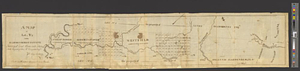
Map from Albany to Crown Point
364.
A map of 100 miles round Boston
365.
Map of a part of no. four, of no. 1 & 2 of no. 3 and of a part of Hague and Cambray
366.
A map of a piece of land surveyd for Peter Coem in lot no 3 belonging the Henry Livingston esqr & laid down from a scale of 10...
367.
Map of Argyle or the Scot's Patent
368.
Map of East Florida from St. Augustine to Tampa Bay
369.
A map of great lot no. 2 in the Hardenbergh Patent
370.
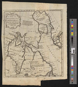
A map of Hudsons Bay and parts adjacent from the latest surveys and best authorities
371.
A map of Jersey Field
372.
Map of land owned by W. Youngs estate on the Brandywine
373.
A map of lot no 1 in the Hardenbergh Patent
374.
A map of lot no 24 in North East Town containing 911 acres : as surveyd in 1794 by Alexr. Thompson
375.
A map of lot no. 35, in the second or Little [Nine Partners Patent]
376.
A map of lot no. 4 in the Hardenbergh Patent : surveyed and run into lots AD 1788 at the request of John R. Livingston esqr.
377.
A map of lot no 4 in the [Ha]rdenbergh Patent
378.
A Map of lot number four In The Division of Macomb's purchase
379.
A map of New England, and Nova Scotia; with part of New York, Canada, and New Britain & the adjacent islands of New Found Land...
380.
Map of New York I. with the adjacent rocks and other remarkable parts of Hell-Gate
‹ Prev
Next ›
1
2
…
15
16
17
18
19
20
21
22
23
…
50
51


![A map of lot no. 35, in the second or Little [Nine Partners Patent]](https://bpldcassets.blob.core.windows.net/derivatives/metadata/commonwealth-oai:dj5314259/image_thumbnail_300.jpg)
![A map of lot no 4 in the [Ha]rdenbergh Patent](https://bpldcassets.blob.core.windows.net/derivatives/metadata/commonwealth-oai:zs262628v/image_thumbnail_300.jpg)