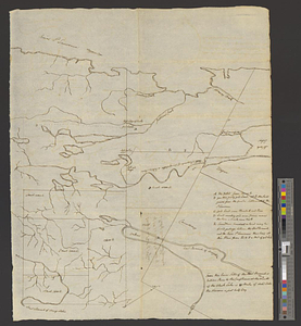
Map of a part of no. four, of no. 1 & 2 of no. 3 and of a part of Hague and Cambray
This map is also available in American Revolutionary Geographies Online (ARGO), a collections portal especially built for material relating to the American Revolutionary War Era. Visit ARGO to learn more about this item and explore the historical geography of North America in the late eighteenth century.
Item Information
- Title:
- Map of a part of no. four, of no. 1 & 2 of no. 3 and of a part of Hague and Cambray
- Date:
-
[ca. 1800]
- Format:
-
Maps/Atlases
- Genre:
-
Manuscript maps
- Location:
- William L. Clements Library
- Collection (local):
-
William L. Clements Library Collection
- Subjects:
-
Saint Lawrence County (N.Y.)--Maps
- Places:
-
New YorkSaint Lawrence (county)
- Extent:
- 1 ms. map ; 52.2 x 42.1 cm.
- Terms of Use:
-
The University of Michigan Library provides access to these materials for educational and research purposes. These materials may be under copyright. If you decide to use any of these materials, you are responsible for making your own legal assessment and securing any necessary permission. If you have questions about the collection, please contact the William L. Clements Library.
Contact host institution for more information.
- Scale:
-
Scale ca. 1:86,000.
- Language:
-
English
- Catalog Record:
-
Catalog record
- Notes:
-
Transferred from Gouverneur Morris Papers (Clements Library).
Pen and ink map of part of St. Lawrence County identifying the parcels described in the title.
Table of references provides further information on the country, and an additional note gives distances on Indian River.
Title taken from verso.
- Identifier:
-
8731
- Barcode:
-
B2812776