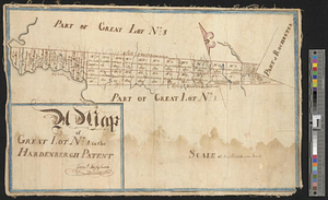
A map of great lot no. 2 in the Hardenbergh Patent
This map is also available in American Revolutionary Geographies Online (ARGO), a collections portal especially built for material relating to the American Revolutionary War Era. Visit ARGO to learn more about this item and explore the historical geography of North America in the late eighteenth century.
Item Information
- Title:
- A map of great lot no. 2 in the Hardenbergh Patent
- Creator:
- Tappen, Cornelius
- Date:
-
[1750–1759]
- Format:
-
Maps/Atlases
- Genre:
-
Manuscript maps
- Location:
- William L. Clements Library
- Collection (local):
-
William L. Clements Library Collection
- Subjects:
-
Real property--New York (State)--Sullivan County--Maps
Hardenbergh Patent (N.Y.)--Maps
Sullivan County (N.Y.)--Maps
- Places:
-
New YorkSullivan (county)
- Extent:
- 1 ms. map : outline col. ; 30 x 47 cm
- Terms of Use:
-
The University of Michigan Library provides access to these materials for educational and research purposes. These materials may be under copyright. If you decide to use any of these materials, you are responsible for making your own legal assessment and securing any necessary permission. If you have questions about the collection, please contact the William L. Clements Library.
Contact host institution for more information.
- Scale:
-
Scale 1:126,720.
- Language:
-
English
- Catalog Record:
-
Catalog record
- Notes:
-
Signed: Corns. Tappen.
Shows individual plots with names of owners.
From Wilson Papers (Clements Library).
- Notes (date):
-
This date is inferred.
- Identifier:
-
7493
- Barcode:
-
B1936287
![A map of lot no 4 in the [Ha]rdenbergh Patent](https://bpldcassets.blob.core.windows.net/derivatives/metadata/commonwealth-oai:zs262628v/image_thumbnail_300.jpg)


