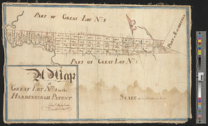
A map of lot no. 4 in the Hardenbergh Patent : surveyed and run into lots AD 1788 at the request of John R. Livingston esqr.
This map is also available in American Revolutionary Geographies Online (ARGO), a collections portal especially built for material relating to the American Revolutionary War Era. Visit ARGO to learn more about this item and explore the historical geography of North America in the late eighteenth century.
Item Information
- Title:
- A map of lot no. 4 in the Hardenbergh Patent : surveyed and run into lots AD 1788 at the request of John R. Livingston esqr.
- Creator:
- Cockburn, James, surveyor
- Name on Item:
-
James Cockburn
- Date:
-
1788
- Format:
-
Maps/Atlases
- Genre:
-
Manuscript maps
- Location:
- William L. Clements Library
- Collection (local):
-
William L. Clements Library Collection
- Subjects:
-
Real property--New York (State)--Delaware County--Maps
Real property--New York (State)--Sullivan County--Maps
Delaware County (N.Y.)--Maps
Sullivan County (N.Y.)--Maps
Livingston, John Robert, 1755-1851
- Places:
-
New YorkDelaware (county)
New YorkSullivan (county)
- Extent:
- 1 ms. map ; 19.2 x 100 cm.
- Terms of Use:
-
The University of Michigan Library provides access to these materials for educational and research purposes. These materials may be under copyright. If you decide to use any of these materials, you are responsible for making your own legal assessment and securing any necessary permission. If you have questions about the collection, please contact the William L. Clements Library.
Contact host institution for more information.
- Scale:
-
Scale 1 inch to 100 chains.
- Language:
-
English
- Catalog Record:
-
Catalog record
- Notes:
-
From: Wilson Papers (Clements Library).
Finished, pen and ink map showing the divisions of the property and giving the names of the owners of this and the adjoining lots.
The property extends eastward from the Delaware River to the "Agreement Line" which bounds the township of Rochester.
- Identifier:
-
8695
- Barcode:
-
B2819840
![A map of lot no 4 in the [Ha]rdenbergh Patent](https://bpldcassets.blob.core.windows.net/derivatives/metadata/commonwealth-oai:zs262628v/image_thumbnail_300.jpg)