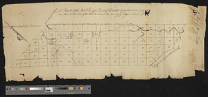
A map of Jersey Field
This map is also available in American Revolutionary Geographies Online (ARGO), a collections portal especially built for material relating to the American Revolutionary War Era. Visit ARGO to learn more about this item and explore the historical geography of North America in the late eighteenth century.
Item Information
- Title:
- A map of Jersey Field
- Title (alt.):
-
Patent dated April 12th 1770 deed of partition of 94000 acres of land on the north side of the Mohawk River in the county of Tryon = called Jerseyfield
- Date:
-
1770
- Format:
-
Maps/Atlases
- Genre:
-
Manuscript maps
- Location:
- William L. Clements Library
- Collection (local):
-
William L. Clements Library Collection
- Subjects:
-
Real property--New York (State)--Montgomery County--Maps
Montgomery County (N.Y.)--Maps
- Places:
-
New YorkMontgomery (county)
- Extent:
- 1 ms. map ; 21.5 x 57 cm
- Terms of Use:
-
The University of Michigan Library provides access to these materials for educational and research purposes. These materials may be under copyright. If you decide to use any of these materials, you are responsible for making your own legal assessment and securing any necessary permission. If you have questions about the collection, please contact the William L. Clements Library.
Contact host institution for more information.
- Scale:
-
Scale ca. 1:47,520.
- Language:
-
English
- Catalog Record:
-
Catalog record
- Notes:
-
From Green Clay Papers (Clements Library).
Map divided into numbered sections.
- Identifier:
-
5577
- Barcode:
-
B1937234


